Flood Awareness Booklet
This brochure is designed to provide you with general information to get you started in your flood protection measures. Your property may be in a flood hazard zone and you may be required to carry flood insurance, though being insured is not necessarily enough to protect your irreplaceable belongings, your pets, your family, or yourself.
Floods Hazards in Mohave County
Floods are the most common natural disaster in the United States. Virtually every U.S. state has experienced floods and everybody has some risk of flooding. In fact, if your property is located in a floodplain, there is a 26 percent chance of experiencing a flood during the life of a 30-year mortgage compared to a 4 percent chance of fire. Any land area susceptible to being inundated by floodwaters from any source is identified as a floodplain.
Natural waterways and the adjacent land are expected to flood during heavy storms. Most of the areas susceptible to major flooding are officially delineated as 100-year floodplains by the Federal Emergency Management Agency (FEMA) on federal Flood Insurance Rate Maps (FIRMs).
FYI: Newcomers to the area are often surprised to learn that the desert holds immense potential for major flooding. Often, normally dry rivers, washes, and channels become raging torrents in minutes.
A 100-year floodplain is an area with a one percent chance of being flooded in any given year. Other areas that routinely flood are also designated on these maps, including areas along flood control channels, elevated railroads, roadways and highways. These are generally referred to as ponding zones. There are some areas in Mohave County that flood frequently but are not recorded on the federal maps.
FYI: Every year property is flooded somewhere in Mohave County. Usually, flooding occurs when natural waterways cannot contain the flow of a large rainfall event.
In August 2014, several local agencies were called out for numerous swift-water rescues. For several hours, a total of 13 people were caught in flooded washes in the Golden Valley area and had to be rescued. Golden Valley Fire Department responded to the first where a family of four was trapped inside their truck. During the same me frame, a mother & son ended up on the roof of their van in the middle of Sacramento Wash until crews from GVFD and Mohave County Sheriff’s Office Search & Rescue arrived. A woman driving a UHaul was swept off of Oatman Highway. Water pushed the moving truck down stream and flipped it backward. She was able to stay on the phone with dispatchers, water filling the cab to nearly the top of the dashboard, until Kingman Fire Department and another crew from GVFD was able to rescue her. The Northern Arizona Consolidate Fire Department assisted the rescues by responding to two adults & four children trapped in their truck on Shinarump Road.
Emergency responders were praised for the “professionalism, bravery and talent” they displayed in the rescues. It is a reminder to never cross flooding washes during rainstorms. Doing so puts your life in danger as well as the lives of the rescuers.
What is the Floodplain?
Longtime Mohave County residents are well aware of flooding hazards in the desert. Many have personally seen the area's normally dry creek beds (also called washes) become suddenly transformed into raging rivers during storm events. When flooding occurs, desert watercourses can overflow their banks and inundate surrounding areas. Major flows in area watercourses can also severely erode unprotected channel banks causing significant damage. During flooding events in Beaver Dam in 2005 & 2010, some residents lost buildings and as much as 165 feet of property due to channel bank erosion.
Certain areas in Mohave County are subject to a special kind of flooding called sheet flooding. Sheet flooding is caused when flood water spreads out over the land surface, rather than running off and collecting into a defined stream channel. Sheet flooding depths can reach six inches or more. Since there is often no defined channel, the path of this type of flooding is highly variable and unpredictable.
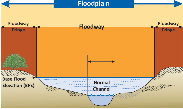
Mohave County regulates all unincorporated areas lying within the 100-year floodplain. The 100-year floodplain is defined as the area adjoining a watercourse that would be covered by water during a flood event having a 1 out of 100 chance (1%) of occurring in any given year. Of course, floods of differing magnitudes -- smaller or larger -- could also occur, each with their own probability of occurring during any one year.
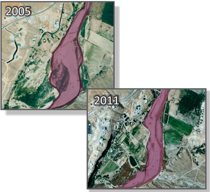
An important first step in evaluating the risk of possible flood damages is to determine whether a property lies within the 100-year floodplain. Floodplains and channels can change significantly over me, whether due to large flooding events or human altering of the landscape. A comparison of the Virgin River floodplain from 2005 to 2011 illustrates these changes.
Natural and Beneficial Functions of Floodplains
Flooding is a natural process that forms and maintains floodplains. Mohave County’s mountain and desert topography lends itself well to the numerous flash flood events that we have each year during severe rainfall events. These seasonal and storm generated variations in water flows, including periodic flooding, are part of the normal function of the floodplain zone.
The lifeblood of these riparian corridors, marshes, beaches, and other natural areas are those periodic flows of water that run down the natural drainage system. The seasonal variability of flow, as well as intermittent extreme events, combine to determine both the physical structure and the biological diversity of flood prone areas.
FYI: If you want to make changes to land within a 100-year flood hazard area, local regulations require you to obtain a permit or authorization before you build, add, grade, install walls or install fencing.
The floodplains control floodwater by allowing it to spread over a large area and reduce velocities, recharge groundwater and filter impurities from runoff, support the riparian habitat, replenish soils, and provide recreational opportunities for walkways, bike paths, open space or conservation.
A floodplain is a fragile environment and can lose its ability to function properly by natural changes or human alteration. Nonstructural management activities, such as the regulation of development in floodplains, keep floodplains clear to function as nature intended. Courtesy of AZ State Parks
Are You in a Flood Hazard Zone?
If you would like to find out if your property is located in a floodplain, you have options:
Take a look at the District FEMA Flood Insurance Rate Maps (FIRMs) online. This interactive map is designed to assist you with determining your property's floodplain status. It is important to note that this map is not an official document that can be used for floodplain determination.
The District will email a Property Floodplain Information report free of charge. Email your requests to MCFloodInfo@mohave.gov. Once you have sent in your request, the District will complete the form with the flood zone and map information and email it back to you. The City of Bullhead City, Lake Havasu City and Colorado City conduct their own floodplain management. Please contact them if your property is within their city limits.
FYI : Flood Insurance is affordable: The average flood insurance policy costs $650 per year. In comparison, a disaster home loan can cost you more than $300 per month for $50,000 over 20 years.
Floodplain Use Permits The District enforces floodplain regulations, which regulate the location and construction of buildings, grading, and other development within designated floodplains. The District may inspect properties to make sure structures or improvements in the floodplain do not cause adverse impacts to properties upstream or downstream.
Before issuing a floodplain use permit, the District undertakes a detailed review of the conditions that affect the subject property, and then ensures that any proposed improvements conform to the County's Floodplain Regulations.
Contact the District at 928-757-0925 to speak with one of our Certified Floodplain Managers before making any improvements or to report unauthorized construction.
In most cases, the federal (and county) floodplain regulations also require that if the cumulative cost of reconstruction, rehabilitation, repair, addition or other improvements over the lifetime of a building equals or exceeds 50 percent of the building's market value, the building must meet the same construction requirements as a new building.
Note: Some uses within a watercourse may also require approval from state or federal agencies.
FYI: It is important that you are aware of natural and artificial drainage systems in your area, so that you don’t disrupt the natural or planned flow of water from your property onto adjacent property.
FEMA Flood Insurance Rate Maps
Flood Insurance Rate Maps, or FIRMs, are maps created by FEMA for the purposes of floodplain management and flood insurance rating. FIRMs are produced to display a community’s base flood elevations, flood zones and Special Flood Hazard Area(SFHA) boundaries. Property owners and community officials can use these maps to determine where a piece of property lies within the floodplain, and to identify flood risks associated within the area.
FIRMs are important because they are the tool the NFIP uses to determine where flood insurance is required, and what the rates for that insurance will be. Federally regulated and insured lenders require all structures located in high-risk areas, as displayed on a FIRM, to carry a flood insurance policy.
To create a FIRM, one of two types of flood studies for a specific area are conducted: an “approximate study” or a “detailed study.” The information gathered is used to identify the SFHA for the areas intended for mapping. All the information is then compiled into a Flood Insurance Study (FIS), which is a narrative document that explains all the findings of the study. Based on that information, FEMA will then generate the FIRM. FIRMs will also typically note common physical features of the vicinity, flood insurance risk zones and floodways, among other aspects of the mapped area.
In the past, community FIRMs were produced on paper foldouts that could take up considerable space. Several years ago, FEMA transitioned from the paper maps to Digital FIRMs (DFIRMs). In Mohave County, the DFIRMs became available in November 2009. Both current and historic FIRMs can be viewed through the FEMA Map Service Center at hps://msc.fema.gov/portal. Mohave County has also developed a FEMA Flood Map Viewer for the internet which is available at hp://femamaps.mohavecounty.us
Occasionally, an engineering study or changes in the physical environment may reveal an inaccuracy in a FIRM or FIS for a given area. When these occasions arise, revisions may be made to the maps and studies by submitting technical data to FEMA under the Leer of Map Change (LOMC) process. This provides an official mechanism for amending or revising the effective Flood Insurance Rate Maps and Flood Insurance Studies. Examples of the LOMC process are:
Letter of Map Amendment (LOMA): A letter based on technical data showing that a property was incorrectly identified as within the SFHA. A LOMA amends the current effective FIRM and establishes that a specific property is not located in an SFHA.
Letter of Map Revision (LOMR): A letter of revision is based on technical data that displays changes (usually of a man-made nature) to flood zones, flood elevations, floodplain and floodway delineations, and planimetric features. One common type of LOMR, a LOMR-F, is a determination that a structure has been elevated by fill above the base flood elevation and is excluded from the SFHA.
Flood Insurance
The Flood Disaster Protection Act of 1973 requires mandatory purchase of flood insurance for buildings mortgaged by federally backed loans that are within an identified National Flood Insurance Program (NFIP) floodplain. First and foremost: Insure! Standard homeowner policies do not cover flood losses, so special flood policies are required to cover the structure and the contents of the home.
Until the National Flood Insurance Act of 1968, flood insurance in flood prone areas was difficult to obtain and expensive to keep. This Act made it possible for structures and their contents to be covered by affordable flood insurance, although these policies do not cover fencing, privacy walls, swimming pools, landscaping or small storage sheds. Coverage for residential or commercial property contents, and/or basements, needs to be purchased separately-a requirement of the NFIP, which is managed by FEMA.
Before granting a loan, lenders are responsible for determining if a building is in a flood hazard zone. If it is, the lender will then either "force place" flood insurance on the structure through an insurance company of their choice, or require proof from the buyer that insurance has already been obtained.
Under the NFIP, flood insurance is available for buildings and contents everywhere within Mohave County, not just buildings within an official flood hazard zone. In most cases, to purchase flood insurance, you will need to acquire a certificate with the elevation of the lowest floor of the structure. Depending on the type of flood zone your property is in, you may have to hire an Arizona Registered Land Surveyor to verify the lowest floor elevation.
Be aware that if your home is flooded and you do not have flood insurance, although you may receive emergency aid such as food and temporary shelter, you may not be eligible for other disaster relief or a low-interest loan to restore those items not covered by insurance.
When you sell your property, you and your Realtor may be held responsible for not disclosing to a buyer or a lender that the property is located within a flood hazard zone.
Because of Mohave County's compliance and overall flood management activities and participation in the NFIP's Community Rang System (CRS), residents of the unincorporated county are eligible for a discount on flood insurance. Currently within a Special Flood Hazard Area, residents can receive a 20% discount and outside a Special Flood Hazard Area, residents can receive a 5% discount due to our Class 6 rating.
To buy a flood insurance policy, call your insurance agent. If your agent does not underwrite flood insurance, or if you do not have an agent, you may call the NFIP's toll-free number, 1-888-379-9531, to obtain the name of an agent in your area.
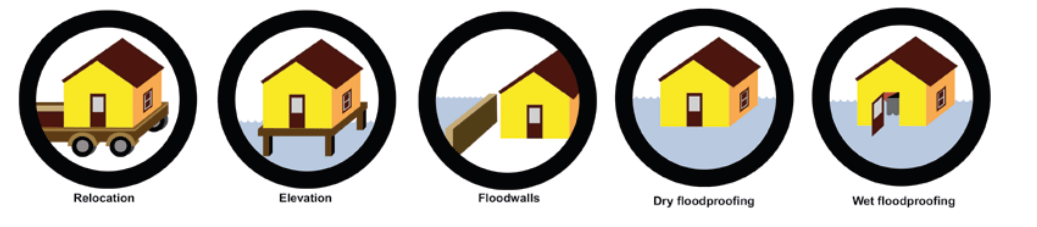
If you carry a Standard Flood Insurance Policy and your home is Substantially Damaged during a flood (cost to repair is more than 50% of the market value), you may be required to bring your home into compliance with current regulations through Floodproofing, Relocation, Elevation or Demolition. You may be eligible to file an Increased Cost of Compliance claim and could receive up to $30,000 to help pay the costs. For more information contact your flood insurance agent.
FYI There are limits to the amount of flood insurance you can purchase. The maximum amounts available are: Single-family homes: $250,000 Other residential: $250,000 Commercial: $500,000 Contents coverage and renter’s policies are also available.
Flood Protection
Your home or business may have been built prior to the present laws and regulations or before the extent of the flood became known. Even if your home was built prior to the flood hazard being identified, there are several things, depending on the severity of the risk, which you can do to further reduce flood damage.
- Make sure the ground around the structure slopes to allow water to drain away from the building. If you cannot raise the structure or its lowest floor, consider lowering significant portions of the yard surrounding it. Be sure to allow for proper drainage to minimize standing water without increasing the drainage onto adjacent properties.
- Use a waterproof coating or siding for the outside walls from below ground to several feet above.
- Build a low retaining wall around the house and keep slide-in panels or sandbags prepared to insert into openings during an emergency.
- Make sure drainage pipes, culverts, drainage easements, washes, and other systems that carry runoff on or near your property are properly maintained and clear of obstructions.
Call your local building permit official or floodplain administrator for a list of floodproofing materials and additional methods of floodproofing.
FYI: Upon request, an MCFCD employee will come to a property for a site-visit, free of charge. Our staff will answer questions about how water flows through your lot. We also offer suggestions for self-protection measures and options for reducing erosion along wash edges.
Seasonal Rainfall
Winter Storms
In Mohave County, the winter storm season occurs from November to March. Winter precipitation is greatest when the storm track enters the state from the west or southwest after picking up considerable moisture from the Pacific Ocean. In fact, some of the most damaging floods have occurred from winter storms outside of Mohave County, such as the Beaver Dam Floods of January 2005 and December 2010 which were the result of rainfall in southwestern Utah.
Monsoon Season
The amount of rain in Arizona varies from year to year, but one event Mohave County residents can count on is the "monsoon" season-June 15 through September 30-a period of frequent thunderstorms and heavy rainfall. A strong annual variation of temperature over a land mass is the primary cause of a monsoon. The end result is a shift in the winds over an area and enough moisture to trigger seasonal rains.
FYI: The monsoon season is more than a nuisance. Monsoon storms are a threat to lives and property.
In Arizona, the process starts with hot and dry weather in May and June. Usually the winds are from a dry westerly direction, so humidity is low and temperatures soar above 95 degrees in the deserts. As the atmosphere warms, the jet stream retreats northward. This allows the winds to shift and bring in the moisture from a southerly direction. Most of the humid air comes from the Eastern Pacific Ocean, the Sea of Cortez (Gulf of California) and occasionally the Gulf of Mexico. Once the moist air arrives, the strong summer sun heats it, causing the familiar thunderstorm clouds.
Accompanying the monsoon season are other natural hazards such as lightning. Arizona ranks 16th in the nation for fatalities due to lightning and 28th for lightning flashes per square mile - remarkable statistics for a state with a very short storm season.
Dust storms and flash floods also cause numerous accidents for drivers. Every year, motorists make the potentially fatal decision to enter flooding wash areas and become stranded, requiring an emergency rescue. In addition, every year winds destroy fences and roofs, knock down utility poles and may cause power outages.
FYI: Mohave County receives 30 percent of its normal yearly rainfall during the monsoon season. Monsoons not only cause heavy rainfall, but also lightning, severe winds, dust storms, and flash floods.
Flood Warning
We live in one of the nation’s largest counties (13,479 square miles), within which are over 5,000 lineal miles of designated floodplains. Often the watersheds feeding these floodplains are small or steep, so the me from rainfall to flooding can be short, sometimes less than an hour.
To monitor conditions in these watersheds, along with our constructed flood control facilities (channels and basins), the District operates a flood threat recognition system called ALERT (Automated Local Evaluation in Real Time). Currently, the District system has approximately 160 rain and stream gages throughout Mohave County and in neighboring areas that affect our watersheds. The gage data is sent by radio waves back to the base station at the District where it is stored and analyzed instantaneously.
District staff members are able to relay the gage readings to the National Weather Service and the Mohave County Division of Emergency Management (MCEM). These agencies use this information to issue the appropriate warnings and prepare for evacuations, if necessary.
FYI: Residents should pay attention to flood watches and warnings issued by the National Weather Service and broadcasted on local television and radio stations. The NOAA Weather Radio All Hazards (NWR) is a single source for comprehensive weather and emergency information.
Call MCEM at 928-757-0930 to learn about evacuation routes, emergency shelter locations, aid for those with access and functional needs, and other emergency information.
You may report flooding, request a site visit or learn where and how to submit a flood damage report by calling the Flood Control District at 928-757-0925 or by sending an email to MCFloodInfo@mohavecounty.us.
FYI: Flash flooding typically results from intense short duration rainfall events, such as the summer monsoons. There may be little or no time for a warning other than a general alert.
Flood Safety
Before a major flood occurs, plan ahead and put together an emergency preparedness kit. Ideas for contents are available at www.redcross.org. If evacuation appears necessary and only if me permits:
- Turn off the electricity at the main power switch and turn off the gas at the main valve. Flood Safety
- Move valuable papers and personal items to upper floors or higher elevations.
- Move outdoor possessions inside, anchor them down or e them together so they won’t be carried away.
- Keep a battery-powered radio handy and tuned to a local emergency broadcast station. Follow all emergency instructions.
- Move to high ground or an established emergency shelter. If it is safe to evacuate by car, take an emergency preparedness kit which should include nonperishable food, water, pet supplies, blankets, a flashlight, dry clothing and any special medications. Be aware that many stores and gas stations will be closed since pumps and registers may not function if electricity has been cut off.
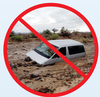
- Do not drive where water covers the road. Part of the road may be washed out or the water may be much deeper than it looks.
If you return to your home and find it has been flooded, air out the home in case of possible gas leaks. Do not turn on gas or electricity until utility representatives have inspected for gas leaks and short circuits. Be sure to also check for structural damage. Report any structural damage as soon as possible to: the phone numbers given on the radio or television; your local building official; the Arizona Department of Water Resources (800-352-8488); or the District (928-757-0925).
Drainage System Maintenance
Stormwater runoff can travel through gutters, storm drains, local channels, and washes before entering delineated floodplains. Damaging flooding can occur along these local drainage sources, as well as within delineated floodplains. Any activity in these local drainage sources must comply with the Drainage Design Manual for Mohave County. The Mohave County Flood Control District is responsible for administering the Drainage Design Manual minimum requirements and guidelines for the unincorporated areas of Mohave County. The purpose of the Drainage Design Manual is to address drainage design and stormwater mitigation associated with development projects under the Mohave County Land Division Regulations and Zoning Regulations.
These regulations ensure that new development does not increase water runoff, divert flows, or back water onto other properties. Regulating new development and enforcing drainage requirements reduces the cost of both future flood damages and remedial flood control measures.
Drainage systems include detention basins, storm drains and flood control channels. Additionally, there are private drainage easements and small washes that may drain surface runoff through your property. Few of these systems involve floodplains or appear on maps.
When you landscape or fence an area, you must be careful not to inadvertently obstruct a drainage easement or another hard-to-detect, yet essential drainageway. Blocking a drainageway can inadvertently cause a diversion or backup of floodwater into your home or onto your neighbor's property. Check with the Flood Control District because it is generally against the law to make such improvements if they have a negative impact on adjacent property. For general questions about drainage call 928-757-0925.
Debris dumped in watercourses can cause stormwater to be diverted around natural or designed watercourses, causing flooding to occur in unexpected areas. The dumping of such items as refrigerators, bathtubs, cars, couches, mattresses, concrete, landscaping materials, soils, boulders, sand, and pet and animal waste in watercourses is illegal and unsightly. To report obstructions or illegal dumping within streams, washes, or drainage facilities within areas of unincorporated Mohave County, call the Environmental Rural Area Cleanup Enforcement (ERACE) Division at 928-715-0480 or the Flood Control District at 928-757-0925.
FYI: The intent is to ensure that drainage is conveyed in a manner that does not adversely impact any property, including other property within a development.
Important Points to Remember
Information and assistance are just a phone call away. To determine if your property is in a floodplain, or for flood protection assistance, please call the District at 928-757-0925 and ask to speak to a Certified Floodplain Manager.
Flood insurance coverage is available for both the structure and its contents.
Single-family residences can now be covered for up to $250,000 on the structure and $100,000 on the contents. Commercial structures can be insured to a limit of $500,000 for the building and $500,000 for the contents.
Buy now! There is up to a 30-day waiting period.
If the initial purchase of flood insurance is in connection with acquiring, increasing, extending or renewing a loan, there is no waiting period. If the initial purchase of flood insurance is made during the 13-month period following the issuance of a revised flood map for a community, there is a one-day waiting period. If a property is affected by flooding on burned Federal Land, there is no waiting period when the policy is purchased within 60 days of the fire containment date. In other cases, there is usually a 30-day waiting period before the policy is effective. For more information, call the National Flood Insurance Program toll-free at 1-800-379- 9531, TTY 1-800-720-1090.
For answers to frequently asked questions regarding flood insurance, please visit: www.floodsmart.gov.
Useful Contact Information
Mohave County Division of Emergency Management 928-757-0930 www.mohavecounty.us Arizona Department of Water Resources 800-352-8488 www.azwater.gov National Flood Insurance Program 1-888-379-9531 www.floodsmart.gov
Printed July 2015
3250 E Kino Ave. Kingman, AZ 86409
Know Your Flood Risk Mohave County Flood Control
mcfloodinfo@mohave.gov
928-757-0925