Arizona Department of Water Resources Presentation to the City of Kingman Date: 7/15/2014
City of Kingman
Meeting of the Common Council
Western Arizona Water Issues of
Concern to the City of Kingman &
Mohave County
July 15, 2014
Gerry Walker
Deputy Assistant Director
Arizona Department of Water Resources
Area of Interest
Topics Requested To Be Addressed
- Brief re-cap of presentation to Mohave County Board of Supervisors regarding creation of AMA or INA
- Industry-standard water conservation practices
- Protocol and schedule for ADWR monitoring in the area
- Water supplies in aquifers that Kingman relies on for municipal water supply
- Projected water use by Rhodes affiliated entities
History – Subsequent AMAs & INAs
- Harquahala INA (1982)
- By Director’s decision after determination that AMA not necessary
- Steep declines in groundwater levels, small annual groundwater recharge and extensive irrigation
- Upper San Pedro (1988)
- Did not meet statutory criteria
- Reviewed in 2001 and still determined AMA not necessary
- Beaver Dam Wash/Littlefield Area (1990)
- AMA proposed to restrict groundwater pumping to prevent transportation out of state
- Election unsuccessful; voted down 70 to 10
- Sacramento Valley (1993)
- Review requested in 1993
- Determined AMA not necessary
- Santa Cruz AMA (1994)
- Created by Arizona legislature
- From a portion of Tucson AMA due to unique circumstances
Designating a Subsequent AMA
Under existing statutes, a subsequent active management area (AMA) may be created in two ways:
- By order of the Director following a public hearing
- By vote of the qualified voters residing in the proposed AMA
NOTE: Single groundwater basin only
Mandatory Regulations in a Subsequent AMA
Irrigation of New Agricultural Lands Prohibited
- Only lands irrigated during previous five years may be irrigated
- Two Exceptions
- Irrigation with previously established surface water rights
- Lands not actually irrigated are deemed to be irrigated if “substantial capital investment” was made “for the subjugation of such land for an irrigation use including on-site irrigation distribution facilities and a well or wells, the drilling and construction of which were substantially commenced before the date of the notice of the initiation of designation procedures or the call for the election.”
Designating a Subsequent INA
Under current statutes, a subsequent Irrigation Non-Expansion (INA) may be created in one way:
- By order of the Director following a public hearing
Subsequent INA
- Proceedings may be initiated by the Director or by petition to the Director by local residents
- Petition must be signed by
- At least 25 irrigation users of groundwater in the proposed INA, or
- At least 1/4th of the irrigation users of groundwater in the proposed INA, or
- At least 10% of the registered voters residing within the proposed INA
Options
Based on an initial review, it appears that the criteria for a Director’s decision designating a subsequent AMA or INA not met
- No significant changes from 1994 report that showed sufficient supplies and did not recommend AMA at that time
- Current USGS studies show similar supplies and demands
Options
- AMA designation may be pursued by vote
- AMA or INA designation may be pursued legislatively
- NOTE: Existing irrigation acres and “substantial capital investment” acres would be grandfathered in
Categories of Municipal Conservation BMPs
- Public Awareness/Public Relations
- Education and Training
- Outreach Services
- Physical System Improvements
- Ordinances, Conditions of Service, Tariffs
- Rebates and Incentives
- Research and Innovation
- NOTE: Kingman GPCD approximately 155
1. Public Awareness/Public Relations
• Local/Regional Messaging
• Events/Presentations
• Market Surveys
2. Education and Training
• Adult Education
• Youth Education
• New Homeowner Landscape Information
• Demonstration Garden
• Distribution Plan for Materials
3. Outreach Services
• Residential Audit
• Landscape Consultation
• Water Budgeting
• Residential Interior Retrofits
• Non-Residential Interior Retrofits
• High Water Use Inquiry Resolution
• High Water Use Notification
• Water Waste Investigation
4. Physical System Improvements
• Leak Detection
• Meter Repair/Replacement
• System Audit
5. Ordinances, Conditions of Service, Tariffs
• Landscape Requirements
• Water Waste
• Plumbing Code
• Landscape Restrictions
• Model Homes Ordinance
• Graywater Ordinance
• Car Wash Recycling
• Watering Restrictions
• Hot Water Devices
• Retrofit on Resale
• Irrigation Efficiency for Non-Residential
• Conservation Tariff
• Water Use Plan
6. Rebates & Incentives
• Toilet Rebate
• HET Rebate
• Toilet Replacement
• Commercial/Industrial Program
• Non-residential Landscape
• No/Low-Interest Loans
• Indoor Fixtures
• Hot Water Systems
• Appliances
• Graywater
• Water Harvesting
• Landscape Conversion
• New Xeriscape
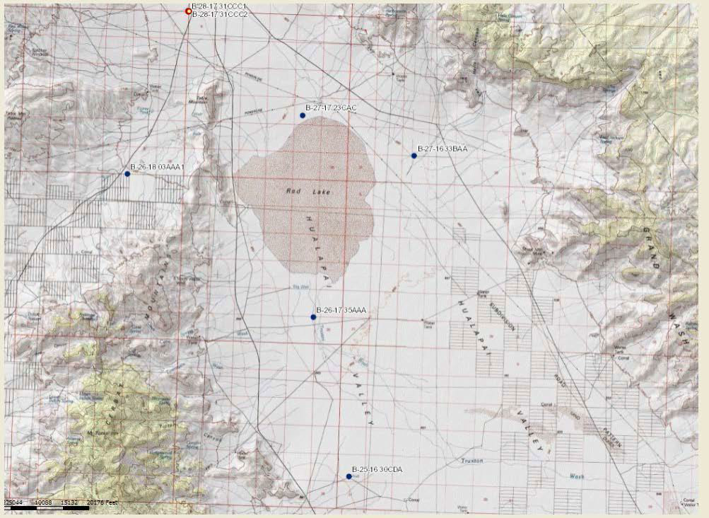
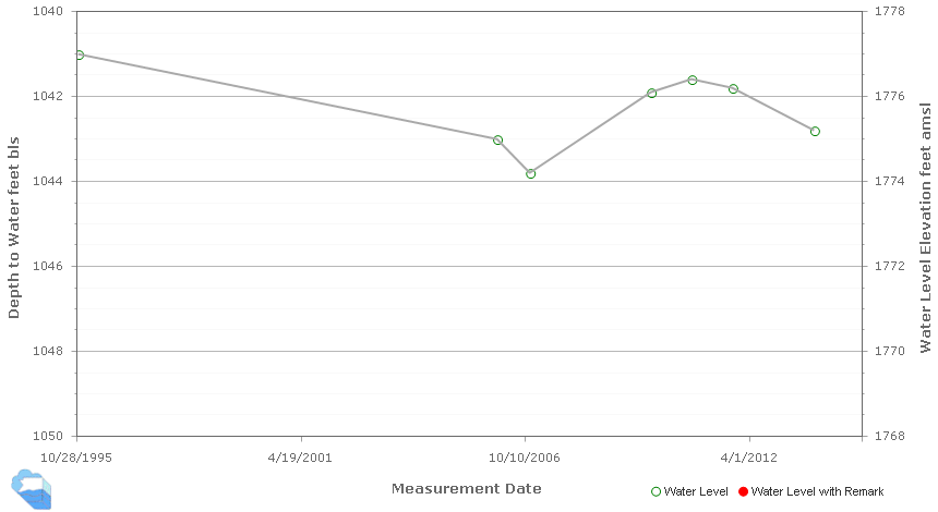
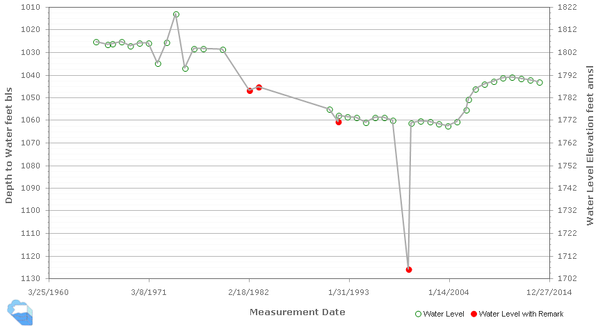
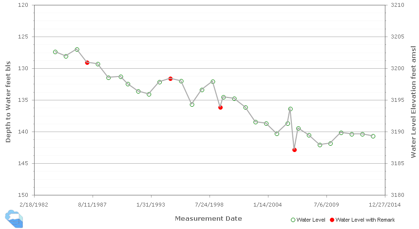
Groundwater Monitoring Protocol and Schedule
Hualapai Valley
- Groundwater levels monitored in approximately 10 wells annually plus two automated monitoring wells with pressure transducers that provide real-time telemetry data
- Well sweep usually conducted in November
- Protocol for monitoring the depth to water below land surface in wells adopted from the USGS
Kingman Area
- Groundwater monitored in approximately 10 wells and three transducer sites
- Same timing and protocol
- Both Hualapai Valley and Sacramento Valley Basin
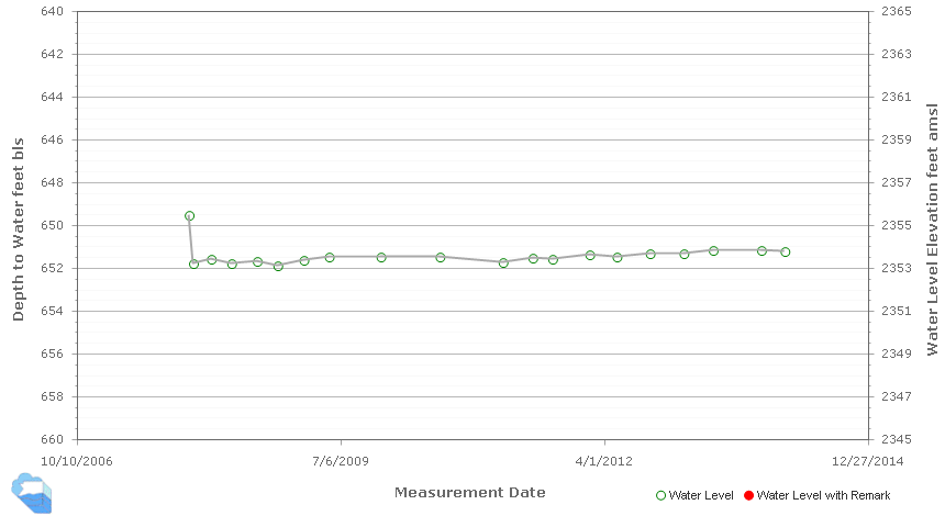
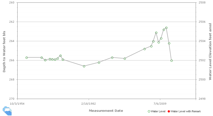
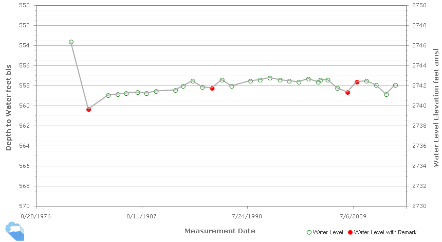

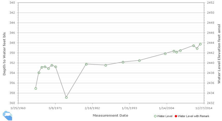
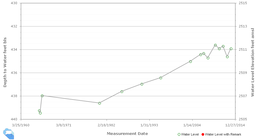
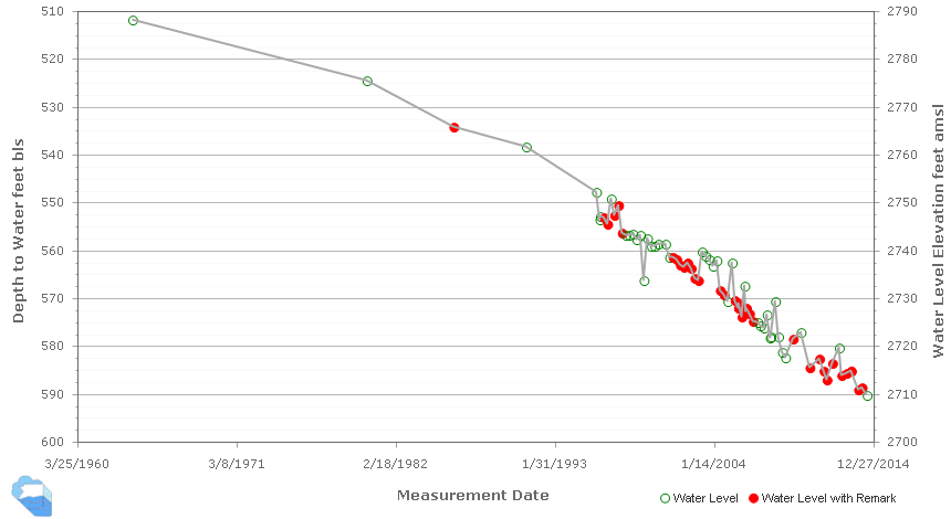
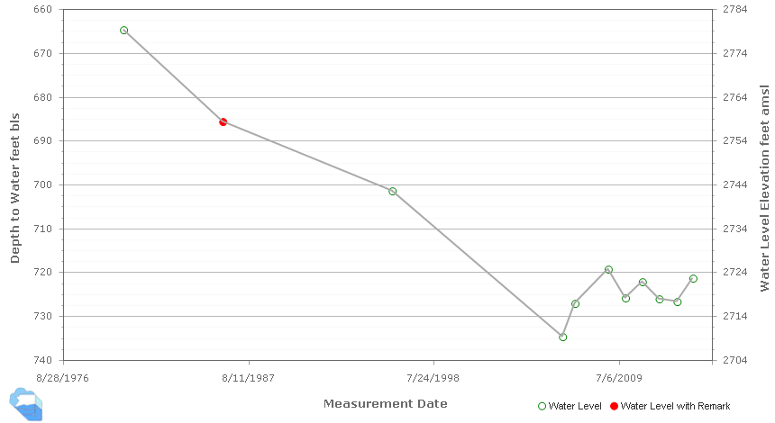
Water Supplies In Aquifers That Kingman Relies On For Municipal Water Supply
- Work done in the Hualapai Valley, Detrital Valley and Sacramento Valley Basins by the USGS in cooperation with ADWR and local governments, including City of Kingman
- Groundwater Budgets (2007-2008)
- Hydro-geologic Framework and Estimates of Groundwater in Storage (2012)
- Preliminary Groundwater Flow Model (2013)
- Following information taken from USGS presentation to Mohave County BOS and referenced reports
Estimated Values of Groundwater Storage for Hualapai, Detrital and Sacramento Valley Basins, Arizona – Information from USGS
Table 4. Estimated groundwater storage in basin fill aquifers to 400 meters below land surface in the Hualapai Valley, Detrital Valley, and Sacramento Valley basins, Mohave County, Arizona.
[ '--' not estimated in analysis; volumes given both in cubic kilometers and acre-feet (in parentheses) ]
| Hydrogeologic unit | Estimated volume of saturated basin fill in km3 | Estimated specific yield, in percent | Estimated groundwater storage in km3 (acre-feet) |
Approximate error, in percent |
Approximate lower boundary for storage estimate in km3 (acre-ft) | Approximate upper boundary for storage estimate in km3 (acre-ft) | ||
| Estimated Volume | Estimated specific yield | Estimated groundwater storage | ||||||
| Hualapai Valley basin | ||||||||
| Saturated fine-grained basin fill (SFBF) | 55 (44.6 million) | 6 | 3.3 (2.7milltion) | 5 | 50 | 50 | 0.05 (40 thousand) | 6.6 (5.3 million) |
| Saturated undifferentiated basin fill (UUBF) | 62 (50 million) | 15 | 9.3 (7.5 million) | 5 | 35 | 35 | 2.9 (2.3 million) | 15.7 (12.7 million) |
| Saturated poorly characterized basin fill (PCBF) | 10 (8 million) | 15 | 1.5 (1.2 million) | 20 | 35 | 40 | 0.3 (240 thousand) | 2.7 (2.2 million) |
| Total, all basin fill sediments to 400 m bls | 127 (102.9 million) | 14.1 (11.4 million) | 26 | 6.8 (5.5 million) | 21.4 (17.3 million) | |||
| Detrital Valley basin | ||||||||
| Saturated undifferentiated basin fill (UUBF and SFBF) | ||||||||
| Sacramento Valley basin | ||||||||
| Saturated fine-grained basin fill (SFBF) | 122 (98.9) | 8 | 9.8 (7.9 million) | 5 | 50 | 50 | 0.1 (81 thousand) | 19.4 (15 million) |
| Saturated coarse-grained basin fill (SCBF) | 16 (13 million) | 6 | 1.0 (810 thousand) | 5 | 50 | 50 | 0.01 (81.1 thousand) | 1.9 (1.5 million) |
| Saturated undifferentiated basin fill (UUBF) | 40 (32.4 million) | 25 | 10.0 (8.1 million) | 5 | 20 | 21 | 6.0 (4.9 milltion) | 14.0 (11 million) |
| Saturated poorly characterized basin fill (PCBF) | 84 (68.1 million) | 15 | 12.6 (10 million) | 20 | 35 | 40 | 2.6 (2.1 million) | 22.6 (18 million) |
| Total, all basin fill sediments to 400 m bls | 217 (176 million) | 35.1 (28 million) | 20 | 21.7 (17.6 million) | 48.5 (39 million) | |||

Projected Water Use
- In 2007, two Analysis of Adequate Water Supply were issued
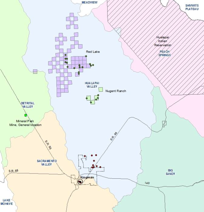
- 63 sections of land included in Red Lake analysis equaling approximately 40,320 acres
- 4 sections of land in Nugent Ranch equaling approximately 2,560 acres
- Groundwater determined to be physically and legally available for Red Lake was 43,432 AF and for Nugent Ranch was 5,648 AF; total 49,080 AF
- Rhodes has indicated 10,000 acres of irrigation; would equal 60,000 AF per year at 6 AF/AC/YR
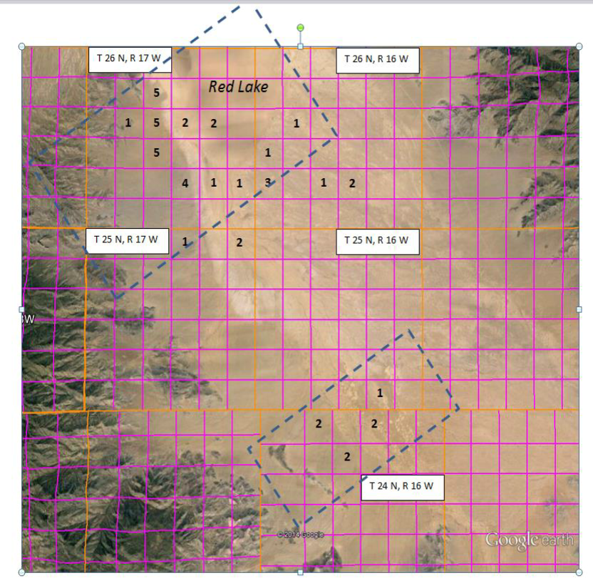
- Since 2013, 44 NOI forms for non-exempt wells received by ADWR for the Red Lakes area
Physical and Legal Availability
- Physical availability of the water is typically demonstrated through a hydrologic study
- Such a study was completed by Rhodes
- Hydrologic study must consider demands of current and committed uses for 100 years
- Kingman’s current and committed demands were included in the modeling done for the analyses
- The depth to water cannot exceed 1,200 feet after 100 years