Hualapai Hearing INA Slideshow Date: 11/12/2022
PUBLIC HEARING ON THE DIRECTOR’S ORDER INITIATING PROCEEDINGS TO CONSIDER DESIGNATING THE HUALAPAI VALLEY GROUNDWATER BASIN AS AN IRRIGATION NON-EXPANSION AREA
June 23, 2022 Letter from Mohave County
- On June 23, 2022, the Mohave County Board of Supervisors requested that the ADWR Director take “whatever actions available and necessary to designate the Hualapai Valley Groundwater Basin as a subsequent INA”.
- The Board of Supervisors cited to updated USGS modeling and "ongoing and extreme drought conditions" as part of the bases for the request.
- By letter dated June 24, 2022, the Director indicated that ADWR would review updated modeling and other relevant information, including current and projected drought conditions and receive public comments on whether to initiate designation procedures.
Informal Public Meeting
On September 20, 2022 the Arizona Department of Water Resources (ADWR) held a public meeting to present information on hydrology, preliminary results of groundwater modeling of current conditions, and accept public comments on whether the Director of ADWR should initiate procedures to designate the Hualapai Valley Groundwater Basin as an Irrigation Non-Expansion Area (INA).
Comments and Questions Received During the Informal Public Meeting Record
In response to comments and questions received during the informal public meeting record period, ADWR updated its webpage for this matter to include all the comments received and a document addressing answers to specific questions, including relevant modeling files relied upon during ADWR's review.
Those comments, questions and answers can be found at https://new.azwater.gov/hualapai-valley-ina-request
Water Adequacy Determinations
The Department received questions about water adequacy determinations issued for new subdivisions in Hualapai Valley. All water adequacy determinations in the Hualapai Valley basin that groundwater would be physically available for 100 years were issued prior to the release of the USGS numerical models. The USGS numerical models provide more accurate information about the likely effects of additional pumping.
- 53 Water Reports. 53 water reports determining 100-year water adequacy have been issued to landowners for proposed subdivisions. Of those 53 water reports, 46 were issued as inadequate water supply reports and seven were issued as adequate water supply reports. The most recently issued adequate water supply report was issued in 1981 based on hydrologic information presented to ADWR at that time.
- One Analysis of Adequate Water Supply. An analysis of adequate water supply was issued in 2006 for Mardian Ranch based on a hydrology study completed in 2006, prior to the release of the USGS numerical models. In 2021, ADWR granted a second five-year extension for this analysis. Under ADWR rules, ADWR may not consider hydrologic information in determining whether to grant the first and second five-year extensions of an analysis. See A.A.C. R12-15-712(H).
- Two Designations of Adequate Water Supply. Two designations of adequate water supply were issued to City of Kingman and Cerbat Water Company for demands within their service areas. Those designations were issued in 1973 and 1998, respectively, based on hydrologic information available at that time.
Director’s Order
Based upon hydrologic information and public comments received, on October 12, 2022, the Director signed an Order to initiate procedures to consider designating the Hualapai Valley Groundwater Basin as an INA.
Public Hearing
In the same Order, the Director also ordered a public hearing. Today’s public hearing is to receive evidence both orally and written, as to the following:
- Is there an insufficient groundwater supply to provide a reasonably safe supply for irrigation of the cultivated lands in the area at the current rate of withdrawal?
- Is the establishment of an active management area pursuant to A.R.S. § 45 412 not presently necessary?
- Should the Department issue an Order designating the Hualapai Valley Groundwater Basin as a subsequent irrigation non-expansion area?
Director’s Order & Public Hearing
- At today’s hearing, the Department will present the factual data related to the proposed subsequent irrigation non-expansion area, pursuant to A.R.S. § 45-435(C).
- Any person or authorized representative may appear at the hearing and submit oral or documentary evidence for or against the proposed action.
- Additionally, written comments not submitted at this hearing may be submitted by mail, email, fax, or hand delivery until 5:00 P.M. on November 18, 2022
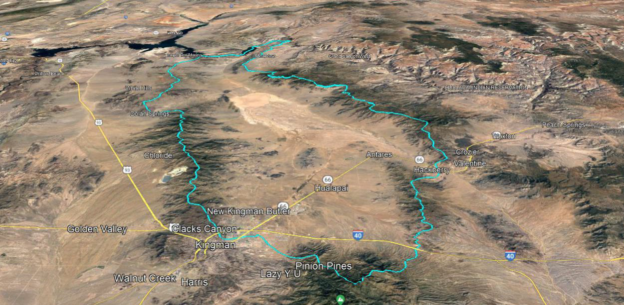
Hualapai Valley Groundwater Basin
Limitation on Number of Irrigable Acres
- Once the procedures to designate an INA were initiated:
- Beginning on the date the Director gives notice of the initiation of the designation procedures (October 12, 2022), only lands that were irrigated at any time during the five years prior to the notice may be irrigated.
- This prohibition on irrigating new lands remains in effect until the Director makes a final determination on whether to designate the area as an INA.
- If the Director decides to designate the area as an INA, the prohibition on irrigating new acres becomes permanent.
Public Hearing
- At today’s hearing, the Department will present the factual data related to the proposed subsequent irrigation non-expansion area, pursuant to A.R.S. § 45-435(C)
- Any person or authorized representative may appear at the hearing and submit oral or documentary evidence for or against the proposed action. Additionally, written comments not submitted at the hearing described above may be submitted by mail, email, fax, or hand delivery until 5:00 P.M. on November 18, 2022 to:
Sharon Scantlebury
Docket Supervisor
Arizona Department of Water Resources
1110 W. Washington, Suite 310
Phoenix, AZ 85007
(602) 771-8472 (phone)
(602) 771-8686 (fax)
sscantlebury@azwater.gov
Director’s Decision
- The Director must issue written findings within 30 days after the public hearing.
- In making his determination, the Director shall give full consideration to public comment and to recommendations made by local political subdivisions. (A.R.S. § 45-435(C)).
- If the Director finds that an INA should be created, the Director must issue an order designating the INA.
- The Director’s findings and order must be published in a newspaper of general circulation in each county where the proposed INA is located once a week for two consecutive weeks.
- The Director’s order is effective when published for the second time.
- The findings and order are subject to requests for review or rehearing and actions for judicial review. Any motion for review or rehearing must be made within 30 days of the second publication of the Director’s order and the Director may grant or deny the motion within 60 days thereafter (A.R.S. § 45-114(c)).
- The Order is effective when published for the final time
- The Director must file a copy of the map identifying the lands in the INA with the office of the county recorder of the county in which the INA is located
What is an Irrigation Non-Expansion Area (“INA”)?
- An INA is a groundwater basin or sub-basin outside of an active management area (“AMA”) where:
- Irrigation of new lands is prohibited
- Measuring and reporting are required for most large wells
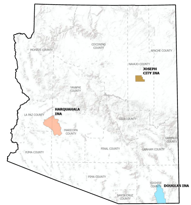
Current INAs
- The 1980 Groundwater Management Act created two Irrigation Non-Expansion Areas:
- Joseph City INA in Navajo County
- Douglas INA in Cochise County
- Harquahala INA was created by Director Decision and Order dated June 24, 1982
Subsequent INAs
- A.R.S. § 45-432 – Authorizes the Director of ADWR to designate a groundwater basin or one or more sub-basins as a subsequent INA if the Director determines that both of the following apply:
- There is insufficient groundwater to provide a reasonably safe supply for irrigation of the cultivated lands at current rates of withdrawal.
- Establishment of an AMA is not necessary (A.R.S. § 45-412). Criteria related to the designation of an AMA:
- Active management practices are necessary to preserve the existing supply of groundwater for future needs.
- Land subsidence or fissuring is endangering property or potential groundwater storage capacity.
- Use of groundwater is resulting in actual or threatened water quality degradation.
Requirements in an INA - Irrigation of New Lands Prohibited
- In an INA, only lands irrigated during the five years preceding the establishment of the INA (or the notice of initiation of proceedings to designate a subsequent INA by the Director) may be irrigated with any water.
- “Irrigate” is defined as applying water to 2 or more acres of land to produce plants or parts of plants for sale or human consumption, or for use as feed for livestock, range livestock or poultry (A.R.S. § 45-402(18)).
- Two Exceptions:
- Previously established surface water rights.
- “Substantial capital investment.” This is a case-by-case analysis.
Procedure to Establish an Irrigation Authority In a Subsequent INA
- Submission of application and documentation
- ADWR verification of data and (upon approval) issuance of Irrigation Authority number (60-)
- Authority number is used for reporting purposes
Requirements in an INA - Mandatory Measuring and Reporting
- In an INA, the following wells must have a water measuring device:
- A non-exempt well (a well with a pump that has a maximum capacity of more than 35 gpm) withdrawing groundwater for an irrigation use.
- A non-exempt well withdrawing more than 10 acre-feet of groundwater per year for a non-irrigation use.
- In an INA, each person withdrawing groundwater from a non-exempt well must file an annual water use report with ADWR.
- ADWR has approved the use of devices and measuring methods other than the installation of meters (A.A.C. R12-15-903).
- These requirements do NOT apply to “exempt wells” – wells with a pump maximum capacity of 35 gpm or less, for non-irrigation use.
- Mountains / desert basins
- 1,000 ft amsl (Lake Mead) to 8,000 ft amsl (Hualapai Mountains)
- No perennial surface water
- Arid to semi-arid
- 5-10” annual precip. on valley floor
- 17” annual precip. in the mountains
Hualapai Valley Aquifer System
Deep alluvial aquifer system
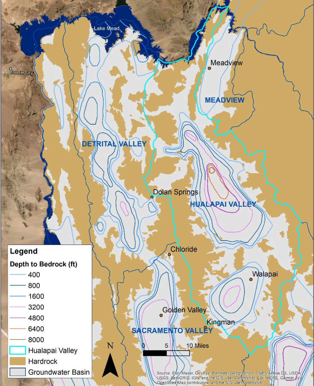
- Natural recharge from washes and mountain fronts
- Depth to water range: 300 – 700 ft bls
- Groundwater flow is to the north
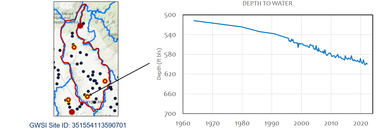
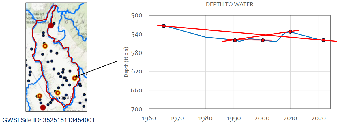
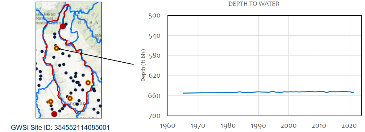
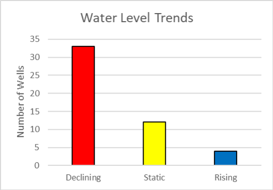
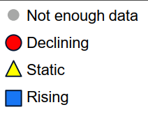
Monitoring Well Trends
- Hundreds of GWSI wells, but many of these have no measurement, only one measurement, or no recent measurement
- We looked at all the data and found 49 GWSI wells with enough recent data for a trend*
- Since 2000, 67% of wells were declining, 24% of wells had a static trend, and 8% of wells were rising
*At least 1 measurement in the last 10 years and at least 2 other measurements since 2000
ADWR Current Conditions Modeling
- Based on USGS 2021 Hualapai Valley groundwater model (Knight et al., 2021)
- Updated municipal demand for 2018 & 2019 provided by Mohave County
- Latest estimate of agricultural demand is 2021
- Based on field surveys
- USGS dataset (Read et al., 2022)
- No future growth in any sector – demands from year 2021 are repeated through the end of the projection (A.R.S. § 45-432(A)(1))
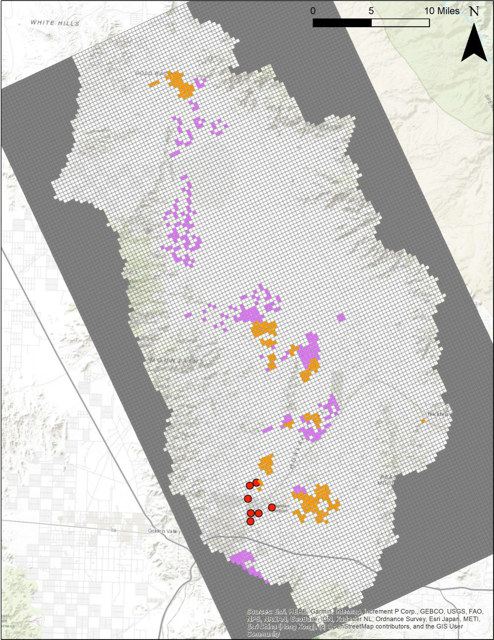
Outflows
Outflows remove water from the model
- Domestic & Industrial – 5,400 AFY
- Natural Discharge – 4,300 AFY
- to Lake Mead / Colorado River
- Municipal Pumping – 8,800 AFY
- Agricultural Pumping (net) – 25,800 AFY
- “net” = total pumped – return flow
Outflows are 44,000 AFY
Source: USGS, 2021; USGS, 2022; Mohave County, 2022
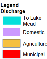
Location of Modeled Ag Withdrawals as of 2021
Withdrawal rates from 2021 were carried forward into the future – no assumed growth
Central section – 6,600 irrigated acres, overhead sprinklers and drip micro irrigation, 80-90% efficiency, mix of orchards, grass, and veggies. 8,900 AFY (~5,500 gpm)
Southern section – 5,900 irrigated acres, drip micro irrigation, 90% efficiency, mix of orchards, vine, and veggies. 13,700 AFY (~8,500 gpm)
Source: USGS, 2022
Depth to Water (DTW) Below Land Surface (bls)
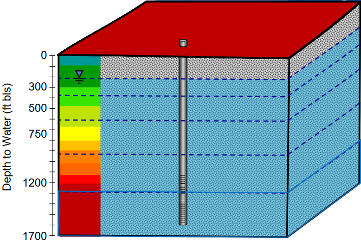
Depth To Water (ft bls)
- 2021 (present)
- 2071 (50 years)
- 2121 (100 years)
Registered Wells
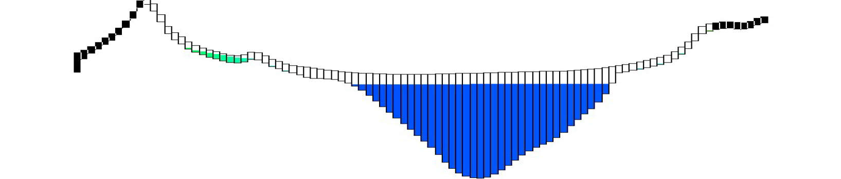
How do existing well depths compare to modeled depth to water after 100 years?
- Starting with the existing, registered wells with a reported depth (>1500, exempt and non-exempt)
- Overlay the 100 yr modeled DTW
- Intersect reported well depth with modeled DTW
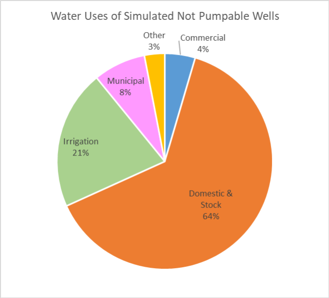
- Results:
- 1 in 20 wells simulated to be not pumpable (assumes 100 ft of water column in well)
- Pie chart shows reported water uses of wells simulated to be not pumpable after 100 years
Additional Information
- Land Subsidence & Fissuring
- ADWR Monitors Subsidence
- Microgravity Surveys
- InSAR Data
- Currently no subsidence observed in Hualapai Valley
- ADWR Monitors Subsidence
- Water Quality
- Groundwater is slightly alkaline, fresh, and hard to very hard based on pH, Total Dissolved Solids, and hardness concentrations
- Some elevated nitrate concentrations (> 3 mg/L)
- Large salt deposit underneath the Red Lake Playa contributes to elevated Total Dissolved Solids in that area
Summary of Hydrology
- At current rates of withdrawal, depth to groundwater will increase
- Greatest change in DTW seen in the south of the basin, near Kingman and Valle Vista
- DTW exceeds 1,200 ft after 100 years between Kingman Airport and Peacock Mountains
- After 100 years of pumping at current levels, ~1 in 20 existing wells are estimated to be no longer pumpable
- For the basin as a whole, outflows are currently exceeding inflows by a factor of 4
- ~10,000 AFY of inflow to the aquifer
- ~44,000 AFY of outflow from the aquifer
Hydrology Sources
Read, A.L., Cadogan, A.F., and Mayo, J.P., 2022, Estimated crop irrigation water use withdrawals in Hualapai Valley Groundwater Basin, Arizona for 2021: U.S. Geological Survey data release, https://doi.org/10.5066/P9GY1WFR
Knight, J.E., Gungle, B., and Kennedy, J.R., 2021, Assessing potential groundwater-level declines from future withdrawals in the Hualapai Valley, northwestern Arizona: U.S. Geological Survey Scientific Investigations Report, 63 p., https://pubs.er.usgs.gov/publication/sir20215077
Information related to today’s meeting will be posted on ADWR’s website here:
https://new.azwater.gov/ama/hualapai-valley-ina-request