Geology of Hualapai Basin - Luis Vega Date: 11/2014
HYDROGEOLOGY OF
HUALAPAI BASIN
Luis Vega
Geologist
November, 2014
(ADWR and USGS maps and data used in presentation)
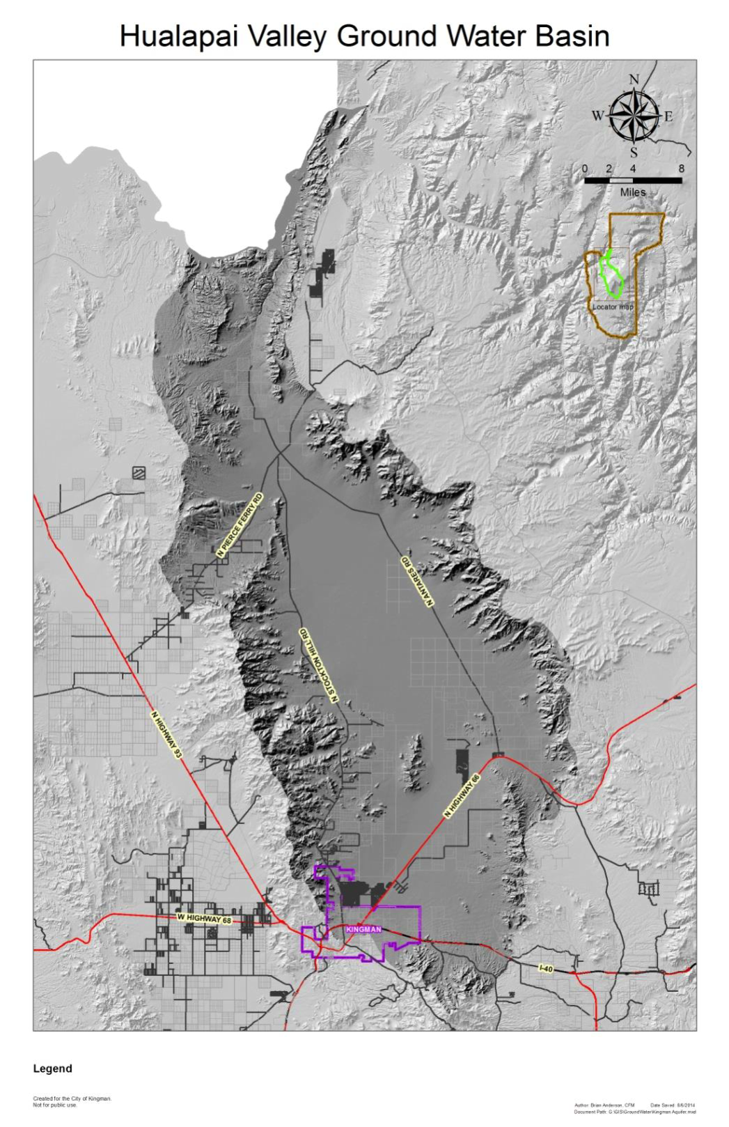
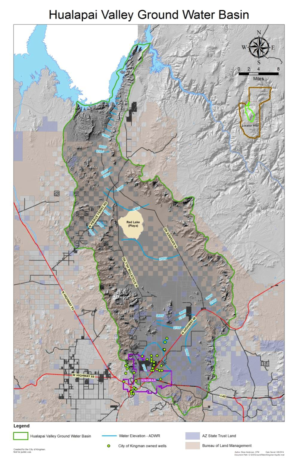
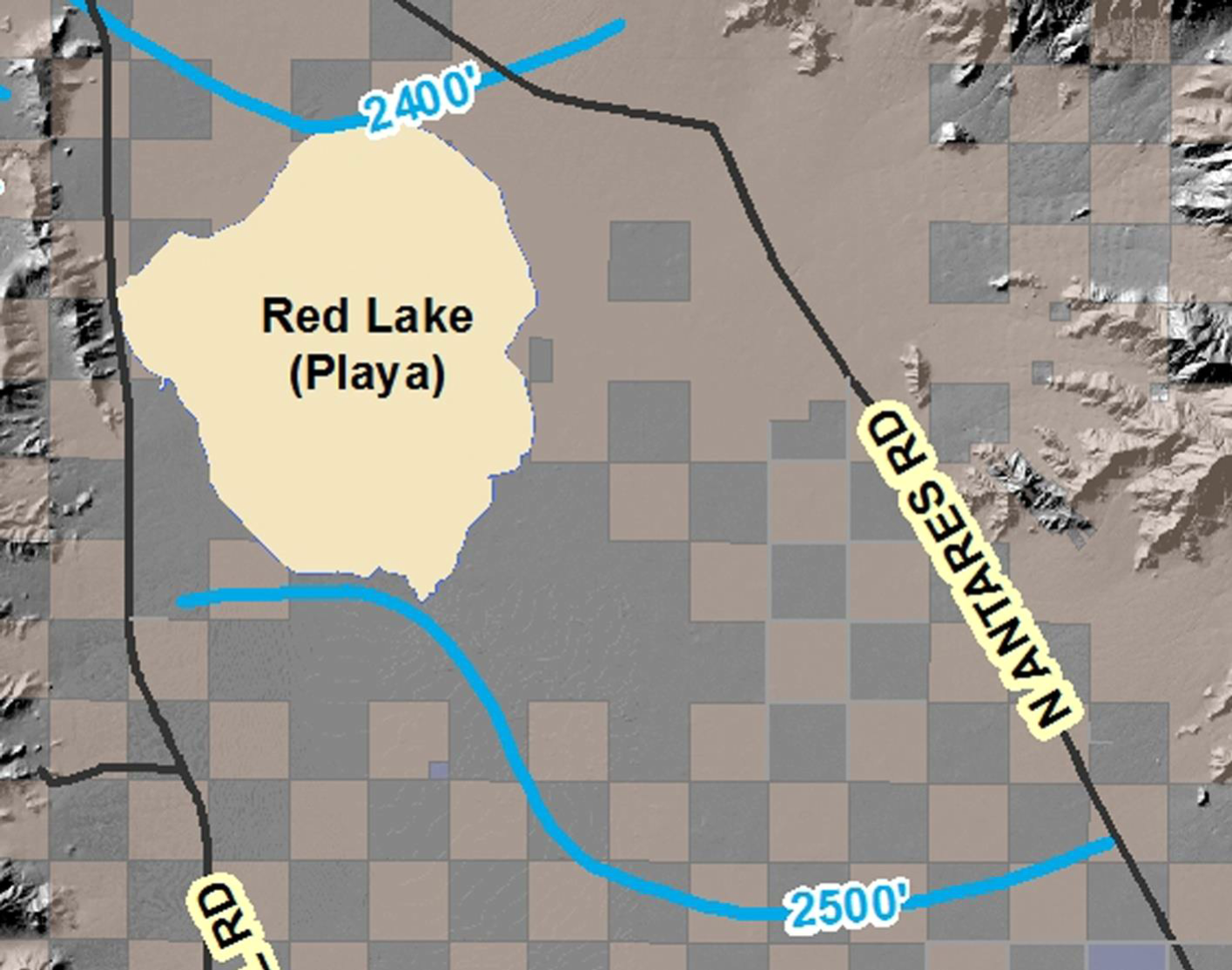
General map of Hualapai Basin. Hydrologic basins are determined by ARS 45-402-13
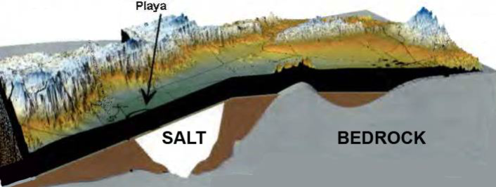
- Water occurs in alluvial valley fill
- Very little water in bedrock
- Different from many parts of the country
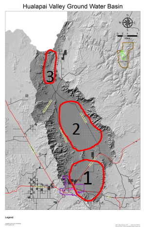
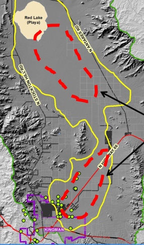
Hualapai basin can be thought of as 3 bath tubs each filled with sand, gravel and water separated by bedrock highs.
Sub-basins
1- Kingman (Airport)
2- Red Lake
3 Gold Basin
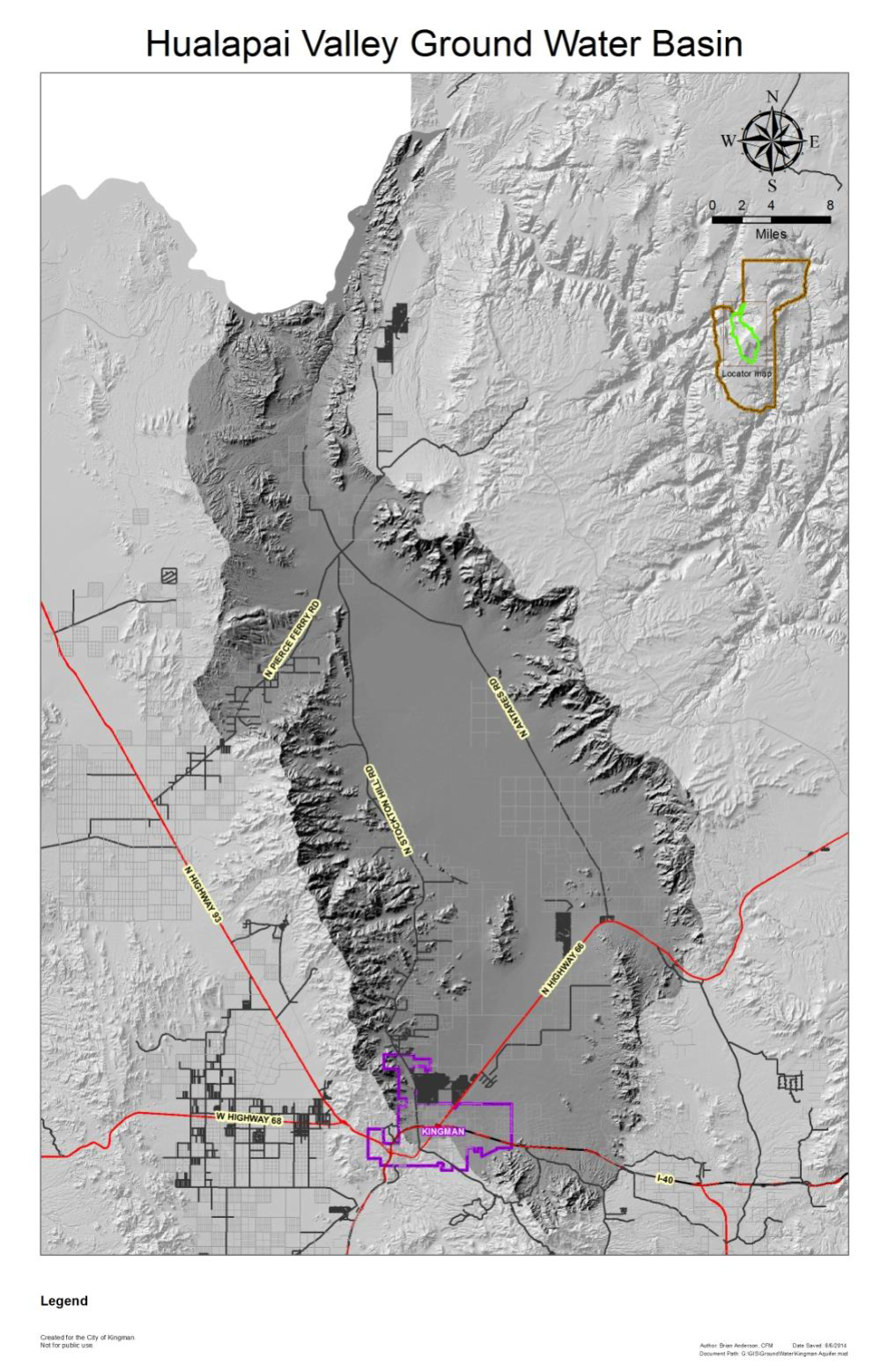
Surface water, in the Kingman and Red Lake part of the basin, is not
connected to Lake Mead. The drainage south of Pierce Ferry Rd. area
flows into Red Lake. The drainage north of Pierce Ferry Rd. goes into
Lake Mead.
At this time the sub-surface flow goes over the bedrock highs and continues north into Lake Mead.
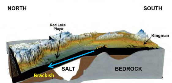
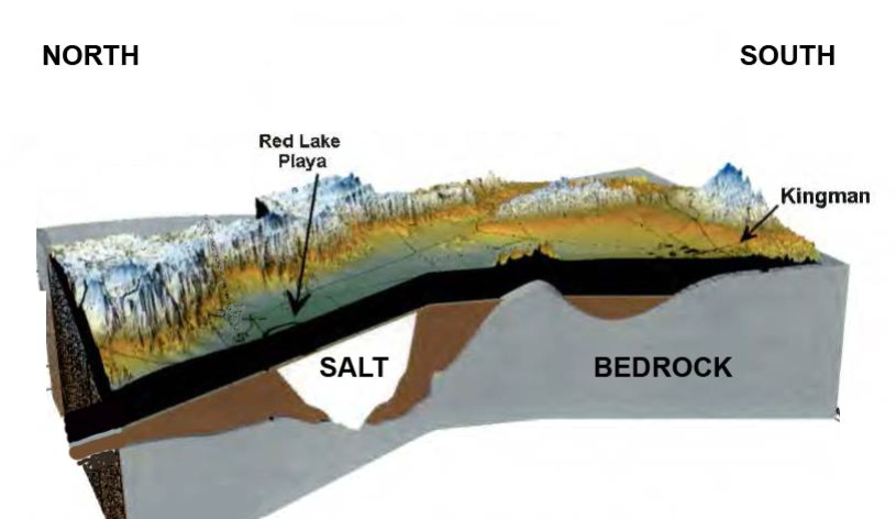
Fresh water near surface, brackish water below 1, 500’ and down
gradient from salt. Salt water has greater density than fresh water.
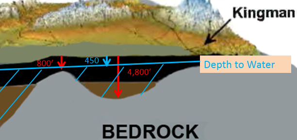
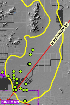
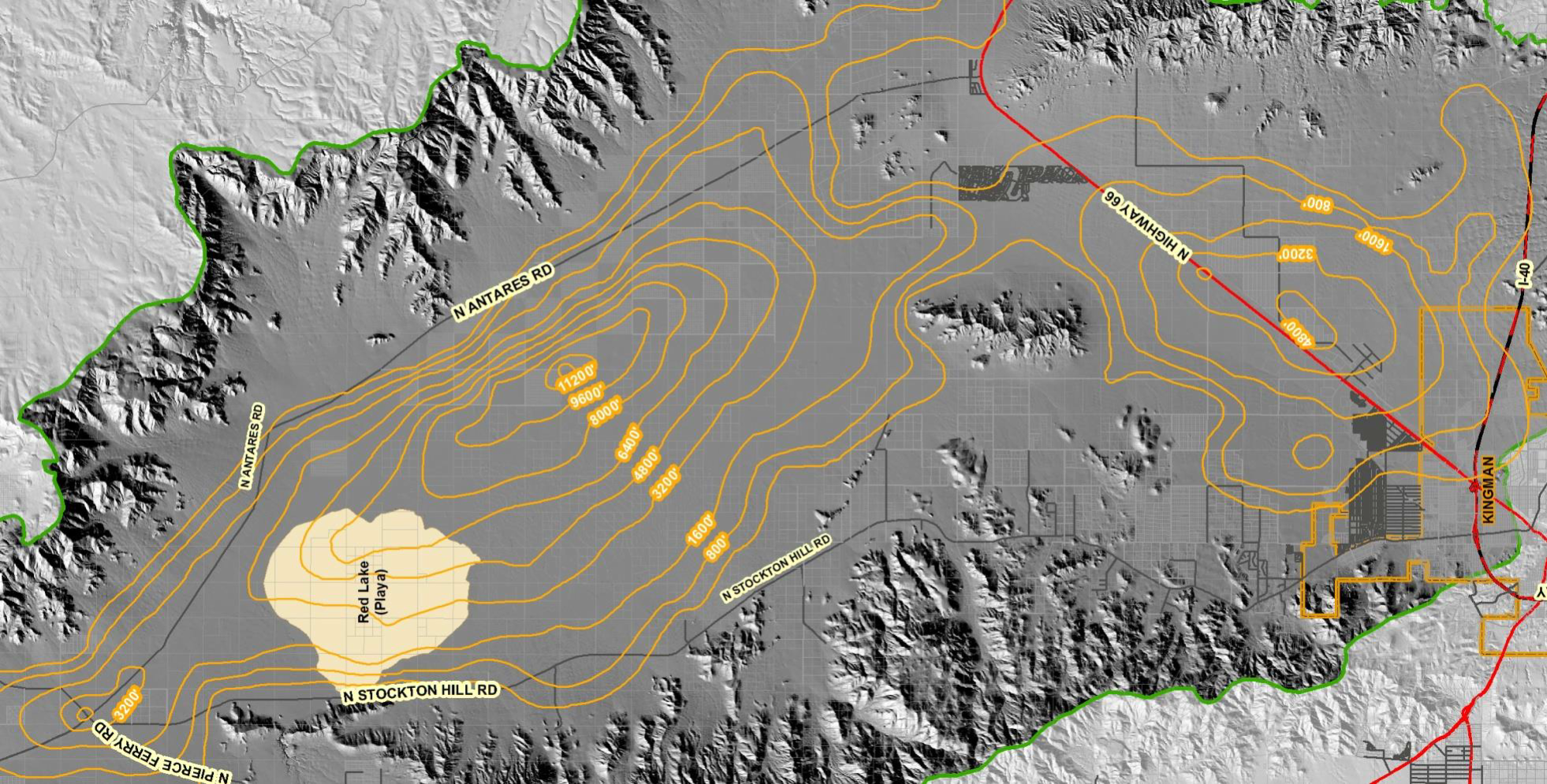
Extent of saturated alluvium-close up-Kingman sub-basin with City well field

Location of City wells in Kingman sub-basin showing depth to bedrock.
Depth to bedrock not only factor controlling distribution of water. Must have favorable sediments such as coarse gravel and sand.
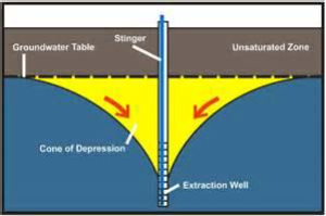
Water does not move fast in the sub-surface.
Arizona GroundWater Monitoring Site Hydrograph
B-22-16 28BAD
Location of well, near Kingman well field, north of Hwy 66, between
Kingman and the airport.

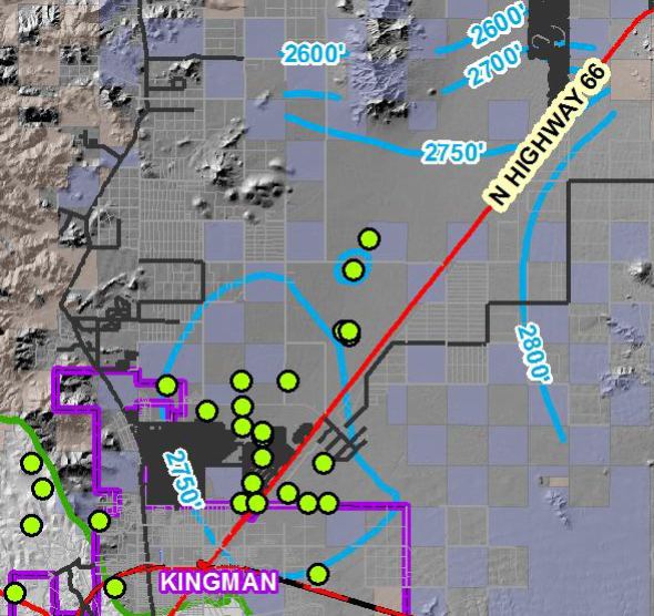

ADWR OFR- 2009 shows a smooth gradient northward.
Groundwater levels should be monitored to measure the impact of recent pumping.
Pumping will eventually form two subsurface bodies of water by dropping the water level below the bedrock high that divides Kingman Sub-basin from Red Lake Sub-basin.
Estimated volume of recoverable groundwater for Hualapai Valley Groundwater Basin (data from ADWR OFR # 11)
| Specific Yield | To 1,200 feet | To 1,500 feet | To 2,000 feet |
| 3% | 3,800,000 | 5,000,000 | 5,600,000 |
| 6% | 7,600,000 | 10,100,000 | 11,100,000 |
| 8% | 10,100,000 | 13,400,000 | 14,800,000 |
| Natural Recharge | In AcFt/Yr | Out AcFt/Yr |
| Mtn-block recharge | 4,400 | |
| Stream recharge | 1,000 | |
| Underflow into basin | 300 | |
| Incidental recharge | 4,300 | |
| Natural Discharge | ||
| To Lake Mead | 5,700 | |
| Evapotranspiration | 200 | |
| Groundwater withdrawals | ||
| Kingman municipal | 8,900 | |
| Community supplies | 500 | |
| Self-supported domestic | 500 | |
| Interbasin transfer | 1,200 | |
| Sub-totals | 10,000 | 17,000 |
| Estimate Kgmn Farms | 25,000 | |
| Estimated Total | 10,000 | 42,000 |
| Basin Status | 32,000 |
Water-Budget Hualapai Basin (USGS SIR 2013-5122 with estimates of Kingman Farm’s water use by presenter)
| Amount of Groundwater being used-2014(simplified) | |
| Kingman Farms ? | 25,000 acre feet/yr |
| City of Kingman, no growth | 8,900 acre feet/yr |
| Other | 150 acre feet/yr |
| 34,050 | |
At this rate, and using 7.6MM acre feet in storage to a depth of 1,200 feet, the water would last approximately 216 years.
Years of Groundwater left, assuming 7.6MM acre feet of water in storage to a depth of 1,200 feet:
| Water Users | Years |
| Kingman + 3% growth | 115 |
| Kingman, 3% growth + Kgmn Farms | 75 |
| Kingman, 3% growth + Kgmn Farms + BLM land | 55 |
(Kingman Farm’s water use are estimates)
Possible Courses of Action
Nothing
INA- irrigation non-expansion area
AMA- active management area
45-433. Local initiation for designation; procedures (INA)
- The designation of a subsequent irrigation non-expansion area may be initiated by the director or by petition to the director of ADWR signed by either:
- Not less than twenty-five irrigation users of groundwater, or one-fourth of the irrigation users of groundwater within the boundaries of the groundwater basin or sub-basin specified in the petition.
- Ten per cent of the registered voters residing within the boundaries of the groundwater basin or sub-basin specified in the petition as of the most recent report compiled by the county recorder in compliance with section 16-168, subsection G. The form of the petition shall be the same as for an initiative petition and the applicant for such petition shall comply with the provisions of section 19-111.
45-434. Limitation on number of irrigated acres
A. If procedures are initiated, whether by the director or by petition, for designating an irrigation non-expansion area, an irrigation user may irrigate within the proposed irrigation non- expansion area only acres of land which were irrigated at any time during the five years preceding the date of the notice of the initiation of designation procedures.
B. The limitation on the acres which may be irrigated shall continue in effect until the director makes a final determination pursuant to section 45-436.
History – Subsequent AMAs & INAs (from ADWR website)
•Harquahala INA (1982)
•By Director’s decision after determination that AMA not necessary
•Steep declines in groundwater levels, small annual groundwater recharge and extensive irrigation
| Outside of AMA | INA | AMA | |
| Uses of water | Water pumped for beneficial use | Water pumped for beneficial use |
Water pumped for beneficial use |
| Grandfather rights | No grandfathering | Irrigated land grandfathered |
Water rights are grandfathered |
| Who controls the water | Must follow state-wide regulations |
Must follow state- wide regulations |
Managed by ADWR |
| Irrigation | No regulations | No new irrigation allowed |
No new irrigation allowed |
| Monitoring of wells | No measuring devises required on wells | Measuring devises required on non- exempt wells |
Measuring devises required on non- exempt wells |
| Reporting | No reporting required | Annual reports required from non- exempt wells |
Annual reports required from non- exempt wells |
| Conservation | No mandated conservation requirements |
No mandated conservation requirements |
Mandated conservation requirements |
Active Management Areas (AMAs)
In the Phoenix, Prescott, and Tucson AMAs, the primary management goal is safe-yield by the year 2025.
Safe-yield is accomplished when no more groundwater is being withdrawn than is being annually replaced.
What would be the management goal for the Hualapai Basin if it were made an AMA?
A decision to pursue a course of action should take into account Unintended consequences.
Disadvantages of AMA in Hualapai Basin:
- What would the goals of an AMA be?
- Hualapai Basin is already in a deficit.
- No new surface water available such as the CAP.
- Safe-yield (use = recharge) cannot be attained even by stopping growth.
- Management of water resources would be under ADWR control.
- Monitoring of groundwater and conservation measures can be accomplished by the County and not relegated to ADWR.
Advantages of an INA in Red Lake Sub-basin-
- A limit on land being irrigated would be immediately placed by the Director of ADWR upon receiving petition.
- Kingman growth would be possible because the 100yr assured water supply requirement could be met.
- ADWR would not be able to limit the use of water in Mohave County.
- Non-exempt wells would have to be monitored and water use reported to ADWR.
What is the future of Hualapai Valley?
•Groundwater is being mined, without other sources, the Hualapai aquifer will run dry.
•Stop low priority, high volume uses of water- (agriculture).
•Improvements in aquifer recharge are needed - capture all runoff into recharge ponds.
•Water conservation measures should be implemented by the County but conservation cannot meet total needs.
•Must secure other sources of water (coordinated with other states possibly through Colorado River or ?).