Overview of Community Let’s Talk Meetings
This Plan shows how each community was given the opportunity to identify their strengths and weaknesses and as well as growth potentials and vision within their specific areas. Let’s Talk meetings were conducted in fourteen communities throughout the County. Goals were identified and committees formed for the top one to three goals.
MOHAVE COUNTY COMMUNITY MEETING OVERVIEW
|
KEY TAKEAWAYS
- Hopeful Economic Outlook
- Rich History
- Recreational Opportunities
- Low Cost of Living
|
MEETING RESPONSE
14 Outreach Meetings Conducted
246 Participants
163 Surveys
|
|
BIGGEST COMMUNITY CHALLENGES
- Need to expand on workforce and training programs as well as supportive businesses such as daycares.
- Paved and dirt roads need improved.
- Future water availability is a concern.
|
SIMILAR COMMUNITY GOALS
- Community generators are needed to support lack of power during extreme heat and cold weather. Specifically for elderly and disabled residents.
- Community gardens and food pantries are needed.
- Beautification to encourage new business, tourism, and film development.
|
At the end of each “Let’s Talk” meeting, each community was guided through a process to create committees to work on at least one goal. By doing so, the communities started to take ownership for their own areas. Each community appointed a community lead. The lead meet with their committees, give encouragement and listen to challenges and need. The lead is also the catalyst to energize and unite the committees. The leads then report quarterly to the Economic Development team. During the quarterly meetings, the Economic Team offer resources and support to the communities. Communities are given time to network with other communities, share their successes, and work together on needed resources. The leads then take information back to their own communities for implantation.
Currently, resources including funding is almost nonexistent. It is hard for the County to offer limited resources, especially, the lack of financial resources. The communities are preparing to partner with non-profit organizations for the ability to apply for grants and request donations. A large challenge is finding local volunteers in support of their goals. Some of the communities are getting excited, even with the very small successes they are seeing. One of the benefits of having community committees, is the community is taking responsibility and ownership for what happens in their own area and not expecting the County or city to provide everything for their area.
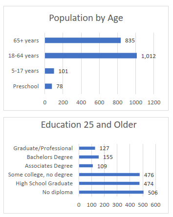
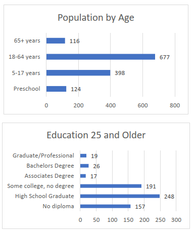
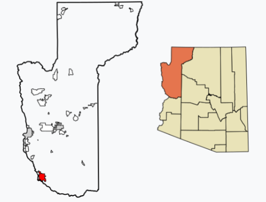
Beaver Dam Community Area
Areas include Beaver Dam, Littlefield, and Scenic (by alphabetical order).
| 2021 Population |
% Change from 2010 |
Median Age |
| 3,926 |
10% ↑ |
61 |
This area is sandwiched between Mesquite, NV, and the southwestern border of Utah. Limited retail is within the three communities so other than convenience stores, all shopping must be done either in Nevada, Utah, or online. The residents love their open space and larger lots. Approximately half of the residents called “snowbirds” reside during the winter months usually November to March and have their main home in colder climate areas during the summer months. The community welcomes growth in the area but is very vocal about where it can be located. The area has a possibility for enhanced outdoor recreational programs and activities. Toy haulers are frequently seen with OHV’s, motorbikes, and mountain bikes. Tourism is one industry that should be a first focus for development.
| Socio-Economic |
| Median Household Income |
$30,745 |
| Poverty Rate |
26.6% |
| Number of Employees |
1,059 |
| Unemployment Rate |
10.4% |
| Language Spoken (English) |
66.4% |
| All Other Languages |
33.6% |
| Housing |
| Total Households |
1,778 |
| Total Units |
2,276 |
| Vacant/Vacation Rentals |
19.3% |
Community Needs
| Committee #1 |
Food security and additional resources for the food bank |
| Committee #2 |
Additional communication resources other than social media |
| Committee #3 |
Tourism expansion |
| Committee #4 |
Community amenities such as a library, community center, and senior center |
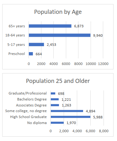
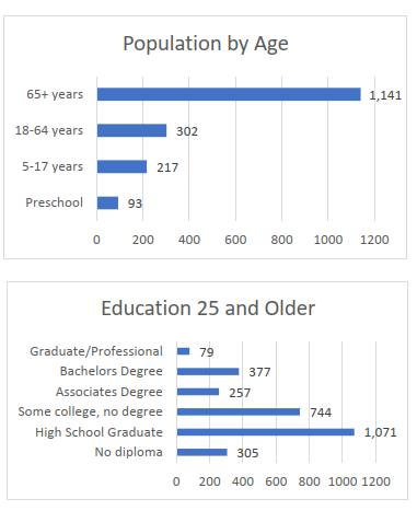
Bullhead City Community Area
Areas include Bullhead City.
| 2021 Population |
% Change from 2010 |
Median Age |
| 41,064 |
9.6% ↑ |
51.5 |
Bullhead City is the second largest city in Mohave County and is on the far western border of the county, bordering the Colorado River and Laughlin, Nevada. Many residents from Bullhead City work across the river in neighboring Laughlin and reside in Bullhead City. Bullhead City is the retail hub for the Colorado River communities. Tourism is the main economic driver for the city and hosts something for everyone. With water sports, sports teams, golf courses, and desert sports as well as community activities, Bullhead City is always inviting. Bullhead City is also becoming a film destination.
The city is ready to support new growth with processes in place to incentivize and speed the permitting process. The City does have a problem with homelessness and look additional services for lower income families.
| Socio-Economic |
Value |
| Median Household Income |
$43,368 |
| Poverty Rate |
19.9% |
| Number of Employees |
16,793 |
| Unemployment Rate |
9.1% |
| Median Travel |
23.1% |
| Language Spoken (English) |
89.7% |
| All Other Languages |
10.3% |
| Housing |
| Total Households |
18,586 |
| Total Units |
24,155 |
Community Needs
| No Committee's |
Services for low-income families and homelessness |
| Were Formed |
Affordable housing |
| |
Additional healthcare options |
| |
More qualified educators |
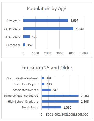
Colorado City Community Area
Area includes: Cain Beds, Centennial Park, Moccasin, Pipe Springs, Town of Colorado City Arizona and Apple Valley and Town of Hildale, Utah. (in alphabetical order)
| 2021 Population |
% Change from 2010 |
Median Age |
| 8,139 |
-23% ↓ |
26.9 |
The Colorado City Community Area resides on the border of Arizona and Utah in an area known locally as Short Creek Valley, rich in pioneer heritage and a storied past. The primary municipalities are Hildale City, Utah, and the Town of Colorado City, Arizona. The area is surrounded by Canaan Mountain Wilderness and Kaibab National Forest, which includes Pipe Spring National Monument. As outdoor enthusiasts look for places to test themselves, hiking activities such as rock climbing, mountaineering, hillwalking, and scrambling have quickly drawn tourism to the area. Furthermore, the community looks forward to developing economic opportunities such as camping and RV parks.
| Socio-Economic |
Value |
| Median Household Income |
$38,562 |
| Poverty Rate |
25.5% |
| Number of Employees |
2,342 |
| Unemployment Rate |
8.9% |
| Median Travel |
16.3% |
| Language Spoken (English) |
98.5% |
| All Other Languages |
1.5% |
| Housing |
| Total Households |
1,255 |
| Total Units |
1,528 |
Community Committees And Goals
| Committee #1 |
Fire Department/EMT support and incentives for volunteers |
| Committee #2 |
Tourism, welcome center, and beautification |
| Committee #3 |
Community center with rec center, convention center and events center included. |
| Committee #4 |
Recruitment including hotel for tourists. |
Dolan Springs and Chloride Community Area
| 2021 Population |
% Change from 2010 |
Median Age |
| 2,026 |
-8.8% ↓ |
63 |
Dolan Springs is a pass-through community for tourists going to Grand Canyon West, the Joshua Tree Forest, or to dock their boat on the Colorado River. It is a community that wants to grow and by having amenities the same as other communities including a grocery store, health clinic, and attractions it will give tourists a reason to stop. Chloride is an old mining town and boast a restaurant, antique stores, Historical Society and Chamber of Commerce. They feel tourism is and will be their main economic driver. Both communities house mostly families on a fixed income. Chloride has mostly elderly residents.
| Socio-Economic |
Value |
| Median Household Income |
$28,025 |
| Poverty Rate |
37.4% |
| Number of Employees |
534 |
| Unemployment Rate |
6% |
| Median Travel |
48.5 |
| Language Spoken (English) |
1.5% |
| All Other Language’s |
98.5% |
| Housing |
| Total Households |
1,077 |
Community Committees And Goals
| Committee #1 |
Beautification – both communities |
| Committee #2 |
Welcome signs from highway 93 and into town – both communities |
| Committee #3 |
Multi-use community center – Chloride |
| Committee #4 |
Clean up of abandon homes and lots – Dolan Springs |
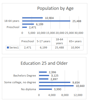
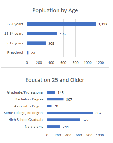
Fort Mohave Community Area
| 2021 Population |
% Change from 2010 |
Median Age |
| 20,768 |
-23% ↓ |
54 |
Highway 95 is the main corridor for the communities. Mostly agriculture is found in much of the land with surrounding smaller communities. Fort Mohave hosts most of their businesses and much of the land is tribal and from the Fort Mojave Tribe out of Needles, California. The area is divided by the Colorado River from California and Nevada. Golden Shores boasts the community center is the gathering place for the community. There isn’t a lot of leadership within each small community. Finding people to step up and become leaders needs to be a huge focus before a lot of growth and move forward. Water rights are also limited from the Colorado River.
| Socio-Economic |
Value |
| Median Household Income |
$49,384 |
| Poverty Rate |
8% |
| Number of Employees |
7,929 |
| Unemployment Rate |
11.4% |
| Median Travel |
23.3% |
| Language Spoken (English) |
87.6% |
| Native American |
12.4% |
Community Committees And Goals
| Committee #1 |
Generator for community center to support elderly and homeless during power outages. |
| Committee #2 |
Enhanced communication |
Golden Valley Community Area
Area includes: Golden Valley, SoHi and Walnut Creek. (in alphabetical order)
| 2021 Population |
% Change from 2010 |
Median Age |
| 9,685 |
-9.6% ↓ |
55 |
The community of Golden Valley lies in the Sacramento Valley separated from the larger neighboring cities of Kingman and Bullhead City by the surrounding mountain ranges. State Route 68 runs through the heart of Golden Valley. They do have some small local businesses that they patronize. The community has larger land parcels, but lacks needed infrastructure. Many people still must haul water to their homes. The community has several new larger companies locating in the southern part of the community but does not have the retail infrastructure to support the growth. This is a community large enough to make huge changes but needs to become unified and find leaders to support their efforts.
| Socio-Economic |
Value |
| Median Household Income |
$41,861 |
| Poverty Rate |
18.5% |
| Number of Employees |
2,628 |
| Unemployment Rate |
4% |
| Median Travel |
24.7% |
| Language Spoken (English) |
77.2% |
| All Other Languages |
22.8% |
Community Committees And Goals
| Committee #1 |
Water conservation, community gardening and composting. |
| Committee #2 |
Film and tourism |
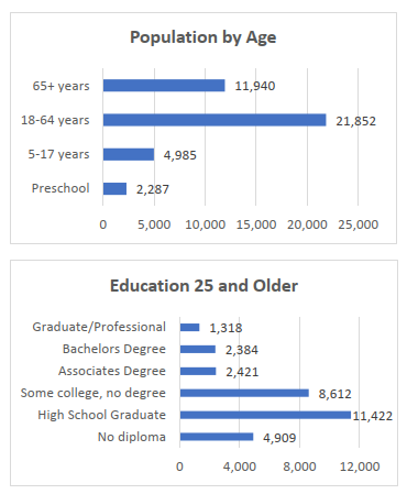
Kingman Community Area
Area includes: Butler and Kingman. (in alphabetical order)
| 2021 Population |
% Change from 2010 |
Median Age |
| 32,204 |
13% ↑ |
41 |
The City of Kingman and surrounding area is constantly growing. Even though Kingman is the County Seat, it is the third largest city in the County. Kingman is just over 100 miles south of Las Vegas and just over 120 miles from Phoenix, making this a prime transportation and tourist destination. The Kingman Industrial Park and Airport is the largest industrial park in rural Arizona and host over 70 employers and over 2,000 employees working at the site. With Route 66 going through the heart of the city, tourists are attracted to the area year-round. The city shows growing pains with the increase in business and residents relocating. Building additional infrastructure is a financial hardship as well as the lack of trained employees. Mohave Community Colleges main campus is in Kingman, and they are preparing to build an Advance Manufacturing Training Center at the industrial park.
| Socio-Economic |
Value |
| Median Household Income |
$45,953 |
| Poverty Rate |
17.9% |
| Number of Employees |
18,513 |
| Unemployment Rate |
7.3% |
| Median Travel |
20min |
| Language Spoken (English) |
86.9% |
| All Other Languages |
13.1% |
Community Committees And Goals
| Committee #1 |
Daycare and supportive services for working families |
| No Committee |
Additional tourism attractions and infrastructure to support tourism |
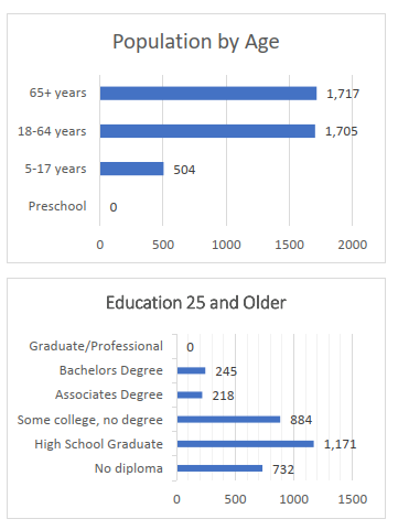
Meadview Community
| 2021 Population |
% Change from 2010 |
Median Age |
| 1,487 |
22% ↑ |
68.4 |
Meadview is a quiet community retirement community with 63% of the population 65 or older and only ½% children 17 or younger. The residents are very supportive of each other and work to make their community a better place. Meadview is just off of Peirce Ferry Road, a tourist destination to launch boats on the Colorado River. This is a small community with very little amenities. Residents must drive to Kingman for health care services, shopping, or other needs. Las Vegas is the next closest location for personal needs at 115 miles from Meadview. The distance makes expanding their community a necessity and a challenge.
| Socio-Economic |
Value |
| Median Household Income |
$50,896 |
| Poverty Rate |
21.1% |
| Number of Employees |
123 |
| Unemployment Rate |
34.1% |
| Median Travel |
No Data |
| Language Spoken (English) |
98.4% |
| All Other Languages |
1.6% |
| Housing |
Value |
| Total Households |
1,711 |
| Total Units |
2,077 |

Community Committees And Goals
| Committee #1 |
Emergency training and supplies including generator for community center |
| Committee #2 |
Community park |
| Committee #3 |
Online training and HIPPA compliant location for Teledoc and online training |
| Committee #4 |
Launch pad installed – increase tourism |
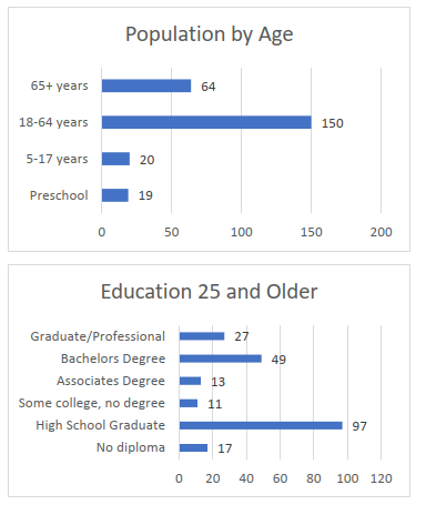
Oatman Community
| 2021 Population |
% Change from 2010 |
Median Age |
| 102 |
-24.4% ↑ |
57.8 |
The community is in the Black Mountains with Route 66 running through town. The town is an old mining community and is heavily visited by tourists. The community takes pride in their rich history, the burros, and the scenic mountain views. Tourism is the main economic driver. At least once a day, the town shuts down the street for a gun fight show. Tourist come by the bus loads to visit the old town and pet the burros that walk the street and try to come shopping with you in the shops. Route 66 is narrower and windier on the east side of town. Precaution should be used for larger vehicles such as busses and RV’s. Instead, they should enter and leave on the west side of town.
Additional information is not available on this community from the US Census.
Community Committees And Goals
| Committee #1 |
Signage to protect the burros stating NO Feeding and speed limit signs |
| Committee #2 |
Build a museum, visitors center and community center in one building. |
| No Committee |
Better public restrooms (would like the county to build) |
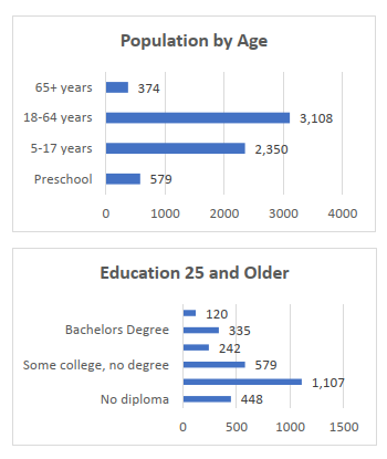
Peach Springs/Hualapai Tribe Community
Peach Springs and Truxton
| 2021 Population |
% Change from 2010 |
Median Age |
| 1,317 |
22% ↑ |
25 |
Peach Springs is the last community on Route 66 before entering Coconino County and 50 miles north- east of Kingman, Arizona. This area is primarily occupied Hualapai Tribal land and occupied and is governed by the Hualapai Tribal Council. The community attributes are small class sizes in the schools, opportunity for businesses to establish and expand and employment opportunities for the residents. There are lots of recreational options and is a good spot for tourism expansion. Mohave Community College has just placed a business incubator in Peach Springs to offer training and support for entrepreneurs. They own and run Grand Canyon West which is their main economic driver for the Tribe.
| Socio-Economic |
Value |
| Median Household Income |
$50,038 |
| Poverty Rate |
33.8% |
| Number of Employees |
446 |
| Unemployment Rate |
14.8% |
| Median Travel |
35.1 mins |
| Language Spoken (English) |
3.3% |
| Native American |
96.7% |
| Housing |
Value |
| Total Households |
345 |
| Total Units |
377 |
Community Committees And Goals
| Committee #1 |
Activities for youth and after school programs |
| Committee #2 |
Affordable housing |
| Committee #3 |
Recruit and educate new leadership |
| Committee #4 |
Grant implementation processes and protocol designed with oversight |
Valle Vista Community Area
Area includes: Hackberry, Valentine, and Valle Vista. (in alphabetical order)
| 2021 Population |
% Change from 2010 |
Median Age |
| 3,102 |
60.3% ↑ |
53.2 |
The communities are northeast of Kingman, along Route 66 in central Mohave County. The community of Valle Vista’s Golf Course attracts not only the local residents but also people from outside the County. With wineries in the area, people can come in, play a round of golf, and enjoy wine in the afternoon. The communities are primarily retirees with some younger families in the Hackberry and Valentine areas. Valle Vista is primarily a residential area and with a few small stores and restaurants frequented by residents.
| Socio-Economic |
Value |
| Median Household Income |
$24,271 |
| Poverty Rate |
16% |
| Number of Employees |
987 |
| Unemployment Rate |
18.2% |
| Median Travel |
33.4 mins |
| Language Spoken (English) |
62.1% |
| All Other Languages |
37.9% |
| Housing |
Value |
| Total Households |
1,564 |
Community Committees And Goals
| Committee #1 |
Fire Department/EMT support and incentives for volunteers |
| No Committee |
Support the growth of the wineries |
White Hills Community
| 2021 Population |
% Change from 2010 |
Median Age |
| 253 |
-2.8% ↓ |
58 |
The White Hills area forms the eastern boundary of the Detrital Valley along Highway 93 in northwestern Arizona. The White Hills are prime for economic growth because of its proximity to major cities, highway access, and available land. The community is 45 minutes from Kingman and 45 minutes from Las Vegas giving choices for health care, shopping, and recreational activities. Many of the residents move to White Hills because they can live off the grid. They are a very close-nit community and support their neighbors. Retail is on Highway 93 and is ready to expand. Tourists enjoy off the grid RVing, UTV/bike trails, and walking trails. Someone new coming in should bring a map and let local people know where they will be exploring in case a search party needs to go out to find them.
| Socio-Economic |
Value |
| Median Household Income |
$53,086 |
| Poverty Rate |
36.7% |
| Number of Employees |
121 |
| Unemployment Rate |
8.3% |
| Median Travel |
No Data |
| Language Spoken (English) |
100% |
| All Other Languages |
0% |
| Housing |
Value |
| Total Households |
129 |
| Total Units |
218 |
Community Committees And Goals
| Committee #1 |
Emergency training including EMT to support life until medical personnel can arrive. |
| No Committee |
Beautification and community center upgrade |
Wikieup Community
| 2021 Population |
% Change from 2010 |
Median Age |
| 71 |
-30.4% ↓ |
46.1 |
Wikieup is a small area southeast of Kingman along Highway 93 towards Phoenix. Wikieup has a cute K- 8 school, a few restaurants and community that pulls together and supports each other. In 2018, the census reported there was a population of 118. In 2021, the census reports there are only 32. This community is preparing for the future I-11 to go through their town and is concerned their community will completely be bypassed. They understand there is much work to do, to grow. They would like to see additional RV parks, a hotel, and someone to start a manufacturing business for people to go to work without traveling over 45 minutes to Kingman.
| Socio-Economic |
Value |
| Median Household Income |
$87,917 |
| Poverty Rate |
18.7% |
| Number of Employees |
6 |
| Unemployment Rate |
0% |
| Median Travel |
No Data |
| Language Spoken (English) |
100% |
| Native American |
0% |
Population By Age
Not Provided by US Census Bureau
Education 25 and Older
Not Provided by US Census Bureau
Community Committees And Goals
| No Committee |
Tourism and beautification |
| No Committee |
New development growth including retail |
Yucca Community Area
Area includes: Desert Hills and Yucca (in alphabetical order)
| 2021 Population |
% Change from 2010 |
Median Age |
| 2,629 |
1.1% ↑ |
64.2 |
Yucca is a very small community directly off I-40 just 25 miles north of the California border. Although it is small, they have a strong community support and pride. The community works well together with Havasu Heights and Desert Hills. One of the joint projects they are working on is an alternative route from Havasu Heights to I-40 through Yucca. Land sizes are larger with limited infrastructure. New businesses must be willing to install all infrastructure to their land. This is a challenge for smaller businesses wanting to come in and support the residents. The largest tourist attraction is the Alien Museum in a large building in the air that looks like a large golf ball.
| Socio-Economic |
Value |
| Median Household Income |
$43,201 |
| Poverty Rate |
16% |
| Number of Employees |
924 |
| Unemployment Rate |
8.6% |
| Median Travel |
14.5 mins |
| Language Spoken (English) |
95.2% |
| All Other Languages |
4.8% |
| Housing |
Value |
| Total Households |
1,406 |
| Total Units |
1,044 |
Community Committees And Goals
| Committee #1 |
Farmers market and flea market stands and expanded food bank |
| Committee #2 |
Community and Senior Center |
| No Committee |
Community Park |
| No Committee |
Educational programs for adults and children |
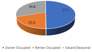
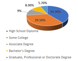
 Housing